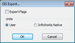
GIS Export dialog
This dialog is used when exporting networks or results to GIS format (MIF, SHP or Geodatabase).
Exporting Networks
When exporting a network, the dialog gives the following options:
| Parameter | Description |
|---|---|
| Export Flags |
Check this option to export flag data. |
| Units | Export using Native Units / current User Units |
| Skip Empty Tables |
Geodatabase only Check this option to exclude empty tables from export. |
| Feature Dataset | Geodatabase only
The name entered here will be used as a prefix for feature classes. |
| Configuration Keyword | Geodatabase only |
| MXD File | Geodatabase only
Check this option to export an MXD file to the path specified in the file box. |
InfoWorks WS Pro carries out all calculations in native units, and converts values to user units for display if necessary.
Exporting Results
When exporting results, the dialog gives the following options:
| Parameter | Description |
|---|---|
| Units | Export using Native Units / current User Units |
| Skip Empty Tables |
Geodatabase only Check this option to exclude empty tables from export. |
| Feature Dataset | Geodatabase only
The name entered here will be used as a prefix for feature classes. |
| Configuration Keyword | Geodatabase only |
| MXD File | Geodatabase only
Check this option to export an MXD file to the path specified in the file box. |
InfoWorks WS Pro carries out all calculations in native units, and converts values to user units for display if necessary.
