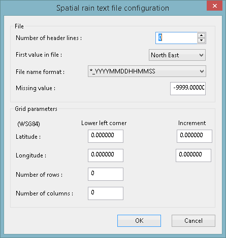
Spatial TSD Geometry Dialog
This dialog is displayed when you click Geometry on the Spatial time series data configuration dialog. It is used to specify or update file information and grid parameters for observed and forecast data which is in the ASCII Grid file format.
Dialog description
| Option | Description |
|---|---|
| Number of header lines |
Number of lines at the top of the text file which should be ignored. |
| First value in file |
Choose the grid location (northern or southern extreme) to which the first row the grid corresponds from the dropdown list. |
|
File name format |
Choose the time format, which is encoded in the file name, from the dropdown list. |
| Missing value | The text used, if any, to denote missing values in the data file. |
|
Latitude & Longitude (Lower left corner) |
The exact coordinates of the centre of the lower left (south west) corner cell. These must be positive values. The datum used is WSG84. |
| Latitude & Longitude (Increment) | The incremental increase to the centre of the next cell. This must be a positive value. |
| Number of Rows | The number of rows in the grid. |
| Number of Columns |
The number of columns in the grid. |
|
OK |
Commit the changes and close the dialog. |
|
Cancel |
Abort the operation and close the dialog. |

