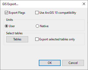
GIS Export Dialog
This dialog is used when exporting networks to on of the following GIS formats:
- MIF
- SHP
- Geodatabase (only available in 32 bit versions of InfoAsset Manager)
Dialog description
| Item | Description |
|---|---|
| Export Flags |
Check this option to export flag data. |
| Use ArcGIS 10 compatibility |
SHP file export only If checked, a direction check on polygons is performed to ensure that all exported single-part polygons are specified anti-clockwise. (Various features in ArcGIS 10 require single-part polygons to be specified anti-clockwise.) |
| Skip Empty Tables |
Geodatabase only If checked, empty tables will be excluded from export. |
| Units | Export using InfoAsset Manager Native Units / current User Units |
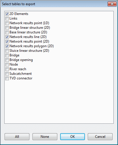
| Select tables |
If checked, export is restricted to a selection of tables. The tables to be exported can be selected when you click Tables. This displays the Select tables to export dialog. Check the boxes next to the tables to be exported. Use the All and None buttons to select or deselect all tables in the list. |
| Feature dataset |
Geodatabase only The name entered here will be used as a prefix for feature classes. |
| Configuration keyword |
Geodatabase only |
| MXD File | Geodatabase only
Check this option to export an MXD file to the path specified in the file box. |