Interpolation Viewer
The Interpolation Viewer is displayed as part of the process of inserting interpolated sections into a River Reach.
The viewer is displayed when using the New interpolated section tool  from the More GeoPlan Tools Toolbar. In interpolate mode, click on a river reach between two sections.
When the viewer is first displayed, the data displayed will allow a single interpolated section to be inserted at the location clicked on. Click the Build button to create the section.
To adjust the number of sections created and to add chords to map specific points from upstream section to downstream section in order to improve the accuracy of the sections interpolated, edit the settings on the interpolation viewer.
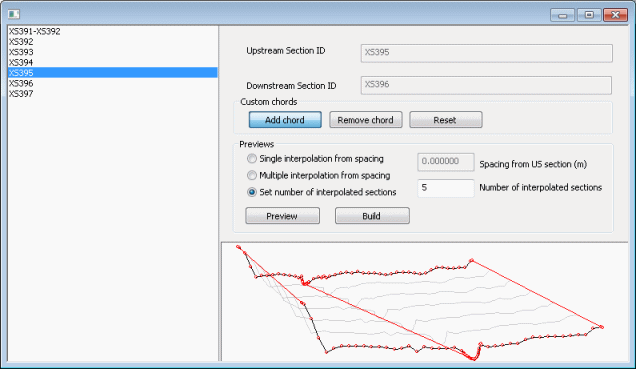
A list of reach sections for the reach clicked on when in interpolate mode is displayed on the left hand side of the viewer. The sections are listed in upstream to downstream order. Select the section upstream of the interpolated section to be inserted. The read-only Upstream Section ID and Downstream Section ID fields on the right hand side of the viewer will automatically be populated.
Custom chords
Interpolation accuracy can be adjusted by the use of "chords". A chord is a pair of XYZ points, one point on the upstream section and one point on the downstream section. These chords are used to and map specific features (e.g. banks and ditches) from one section to another so that they are respected on the generated sections. By default the chords used map the far left, far right and lowest level of the sections.
To add a user defined chord:
- Click the Add chord button
- In the graph view click on a point on either the upstream or downstream section
- Hold the mouse button down and draw a line to a point on the opposite section
Click the Remove chord button and then click on a chord in the graph view to delete a chord
Click the Reset button to revert to the default chords: far left, far right and bed level.
Setting interpolated section spacing
Use the radio buttons in the Previews section to select an option for spacing between interpolated sections:
- Single interpolation from spacing - inserts a single interpolated section at the distance from the upstream section specified in the Spacing from US section field.
- Multiple interpolation from spacing - inserts interpolated sections at distance intervals specified in the Spacing from US section field.
- Set number of interpolated sections - inserts number of interpolated sections specified in the Number of interpolated sections field.
Click the Preview button to refresh the graph view to display the sections that will be created by using the above settings.
Click the Build button to create and insert interpolated sections into the river reach.
