Runoff Models
The runoff data describes the characteristics of the ground surfaces in the system, and the rainfall-runoff model which is used for each. This defines how much of the rainfall falling on the catchment becomes runoff and how quickly it enters the drainage system.
The rainfall-runoff models comprise a set of models enabling engineers to represent the transformation of rainfall into runoff for both urban and rural catchment areas contributing to piped or channelled drainage systems.
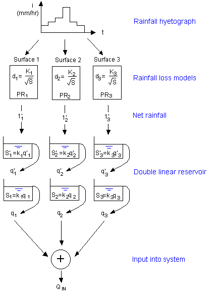
Irrespective of the model option selected there is a basic conceptual framework underpinning the use of the model. First, the overall catchment model is divided into a series of subcatchments. Each subcatchment can then be subdivided into surface types. A surface type is defined for each distinct category of surface. Usually between two and five surface types are sufficient to describe the different areas of a model. Each subcatchment can use up to 12 of the defined surface types.
Overview of surface hydrology model
Twenty-one surface types are defined by default in the database. The default surface types for the default land uses correspond to the three surfaces for the Wallingford Model for UK urban runoff. The three surfaces are shown below:
| Surface Type | Definition |
|---|---|
|
10 |
Paved Surface |
|
20 |
Pitched Roofs |
|
21 |
Pervious Areas |
These surface types will usually be used without alteration for UK catchments. However, in special circumstances, or for use in other countries surface, types can be redefined. Examples of alternative surface types that might be defined are:
- Pervious areas with dense vegetation
- Typical residential areas
- Road drainage
- Industrial areas
Three concurrent processes model the rainfall-runoff:
- Initial losses (depression storage)
- Continuing losses (infiltration)
- Overland flow routing
Conventionally the first two surface types represent impervious (road and roof) areas, whereas the remainder of the subcatchment represents pervious surfaces. The surface runoff model is divided into two major process models, representing rainfall losses and runoff routing, each of which can act independently on the surfaces in each subcatchment (see diagram above).
If you wish to modify the parameters, use the Runoff Surfaces tab in the Sub-catchments Grid Window to define the required parameters
