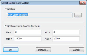
Select Coordinate System Dialog
![]()
 Copyright Statement
 InfoWorks ICM has a default coordinate system that is used for all new networks. The co-ordinates entered for network objects are assumed to relate to this system unless you specify otherwise.
Select Set coordinate system from the GeoPlan menu to display the dialog.
Note: Although 'Longitude and Latitude' options are included in the list of coordinates systems (displayed when you click  and choose an option from the list in the Choose Coordinate System dialog), these options are geographic not projected coordinate systems and therefore should not be selected for use in InfoWorks ICM.
See Selecting the Coordinate System for details about using the dialog.
