Area Take Off
|
Innovyze Howbery Park Wallingford Oxfordshire OX10 8BA United Kingdom +44 (01491 821400 |
|
||
|
Technical Paper December 2012 |
|||

Contents
3. How to conduct ATO in InfoWorks ICM
5. Common Pitfalls in Preparing IAS Data
Appendices
A. Generate Polygons via Intersection
1. Introduction
The area take off (ATO) function calculates any of the twelve runoff areas for each subcatchment from digitised impermeable area survey (IAS) data. The IAS data may be created within InfoWorks ICM or originate from an external Geographic Information System (GIS) layer and imported from a number of formats using one the currently supported map controls; ArcGIS Engine, ArcGIS Desktop and MapXtreme.
Chapter 2 describes the basics of preparing the IAS data, from either a GIS or within InfoWorks ICM. Chapter 3 describes how to conduct the ATO process in InfoWorks ICM. Chapter 4 shows how the calculations are conducted for different combinations of area and system types. Chapter 5 presents common pitfalls in preparing the IAS data and shows how these are dealt with including details of the error log. Appendices Band C present routines in MapXtreme or ESRI products to help with common tasks associated with the preparation of IAS data.
It is recommended that any unusual or invalid IAS polygons are checked by importing them into InfoWorks ICM polygons prior to conducting the area take off. This is described in Appendix A.
2. Preparation of IAS Data
2.1 From a GIS
The IAS data should include a polygon to represent each area which drains to a specified system and surface. For example a house roof that drains to a storm system, or a road that drains to a combined system should each have a polygon.
2.1.1 The System and Surface Code Method
The polygons require two codes: a system type and a surface number. The system type field defines the system type to which the polygon will be assigned. The default system types, defined within InfoWorks ICM are:
- Storm
- Foul (or Sanitary)
- Combined
- Overland
- Other
The surface number field defines the surface number to which the polygon will apply. Numbers from 0 to 12 are acceptable. If the surface number field is given a number from 1 to 12, that is the surface number to which the polygon will apply. If it is given a number 0 it is assumed to act as a soak away and will provide no contribution.
The colour of a polygon has no relevance to the calculation of area, however traditionally the following colours have been used.
|
Impervious Surface Type |
Colour |
|---|---|
|
Drains to Soak away |
Yellow |
|
Paved / Road draining to Foul / Sanitary System |
Brown |
|
Roof draining to Foul / Sanitary System |
Red |
|
Paved / Road draining to Storm System |
Green |
|
Roof draining to Storm System |
Blue |
Table 1 Suggested Polygon Colours
An example of an IAS plan is presented in Figure 1 below.

Figure 1 Example IAS Plan
2.1.2 The Status Code Method
An alternative to the system and surface codes are status codes as presented in Table 2 below.
|
Impervious Surface Type |
Colour |
Code (Surveyed) |
Code (Estimated) |
|---|---|---|---|
|
Drains to Soak away |
Yellow |
Y |
YH |
|
Paved / Road (surface 1) draining to Foul System |
Brown |
BR or BN |
BRH or BNH |
|
Roof (surface 2) draining to Foul System |
Red |
R |
RH |
|
Paved / Road (surface 1) draining to Storm System |
Green |
G |
GH |
|
Roof (surface 2) draining to Storm System |
Blue |
B |
BH |
Table 2 Status Codes
These codes were used, mainly in the UK, before digitising and ATO were available.
There are several limitations with these status codes, including that they only include foul and storm system types and surfaces 1 and 2.
No distinction is made between surveyed and estimated values. Road / Paved areas are automatically assigned to Runoff Surface 1 and Roofs are automatically assigned to Runoff Surface 2. Areas that drain to soak ways (coded Y or YH) are assumed to provide no contribution. These areas are subtracted from the contributing areas.
It is not possible to combine the old and new codes into one table. If ATO is to be conducted using a combination of the old and new codes then they must be split into separate tables and the ATO conducted twice.
2.2 From Polygons Prepared in InfoWorks ICM
Polygons may either be created within InfoWorks ICM or imported using the Open Data Import Centre. Within the polygon grid all the polygons to be considered in the ATO must be given the same category. For the System and Surface Coding (described in section 2.1.1) the User Text is assigned to the System and the User Number to the Surface. For the Status Coding (described in section 2.1.2) the User Text field is assigned to the status codes.
A example of a polygon grid suitable for ATO is presented in Figure 2 below.
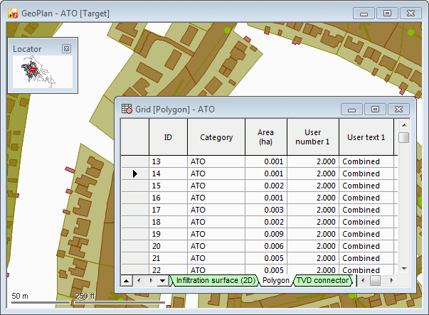
Figure 2 Example of ATO Polygon Grid
3. How to conduct ATO in InfoWorks ICM
The starting point for ATO is an InfoWorks ICM InfoWorks network that has subcatchment areas included. The subcatchment areas can be created within InfoWorks ICM or prepared in an external GIS system using a suitable file format, and then imported into InfoWorks ICM using one of the map controls. The subcatchment layer should include at least the subcatchment boundary, subcatchment type, subcatchment name and preferably the name of the node to which the catchment will drain. An example of a subcatchment layer generated from the thiessen polygon method within InfoWorks ICM is presented in Figure 3 below.

Figure 3 Example Subcatchments

The subcatchments to be updated using ATO must have a #G flag applied to the contributing area in the subcatchment grid.
IAS is conducted by selecting Model > Subcatchment > Area take off.... The dialog box which subsequently appears is shown in Figure 4 below.
Click on the image for additional information about the dialog fields.
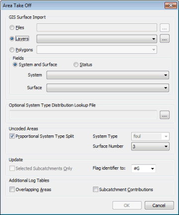
Figure 4 Subcatchment Surface ATO Dialog Box
3.1 GIS Surface Imports
There are three options to import the IAS data. The file option enables browsing for the appropriate file. If the file has been loaded as a layer, the layer option enables selection of the layer. The polygon option selects the polygons within the polygon grid that have an appropriate category chosen.
3.2 Fields
This element provides the choice between the system and surfaces codes method, or the older status codes method. Once a method has been selected, the drop down boxes allow the user to specify which fields from the GIS data supply the codes.
3.3 Optional System Type Distribution Lookup File
A System Type Distribution Lookup File can be used to define the percentage distribution between system types of IAS polygons that contribute to a mixture of system types.
These percentage distributions can be used where:
- IAS polygons contain System Type information
- The system type to have uncoded areas assigned to is specified
and / or
The lookup file is a csv format file containing the names of the mixed system types, as specified in the IAS file, and corresponding percentage distribution between user system types.
3.4 Uncoded Areas
There is a choice of whether the uncoded areas are divided between the four system types in the same proportion as the coded areas, or whether they apply to one specified system type. The surface number entered indicates the runoff surface (1-12) to which the uncoded area is to be applied. If a subcatchment does not contain any coded areas, then it is assumed to provide no contribution.
A full explanation of how uncoded areas are assigned, including examples, is presented in Chapter 4.
3.5 Selected Subcatchments and Flag Identifier
The flag identifier allows the flags on the contributing area and relevant runoff areas to be changed during the ATO process. (Prior to ATO, the flags on these fields must be set to #G).
There is also an option to only update subcatchments that are currently selected.
3.6 The Diagnostic Log
The log file contains two types of messages, errors and warnings. The log will automatically be displayed if any errors are identified. If no errors are identified then any warning messages will only be displayed if the display log box is ticked. Four categories of errors and warnings are reported:
- Missing or invalid data
- Unusual shapes
- Overlapping areas (optional).
- Intersection failure
If the summary table box is ticked, the following tables are produced:
- Subcatchment Area Distribution in metres
- Subcatchment Runoff Areas 1-6
- Subcatchment Runoff Areas 7-12
- IAS Area Contributions for each subcatchment
The areas reported are given in square metres. If available, an ID field is provided for ease of problem location. The Unique ID within the Area Take Off log refers to the row in the Impermeable Area Survey GIS layer. I.e. ID:957, is on row 957 of the GIS data. For the subcatchments the ID is the same as that specified ID in the Subcatchment Grid.
Imported data may contain overlapping areas that could cause inaccuracies in the imported values. Check the Overlapping Areas box to be warned in the log if any overlaps exist.
Check the Subcatchment Contributions box to include summary tables of GIS Area Contributions for each subcatchment.
Producing the log file reduces performance time, however if subcatchment areas are not updated or underestimates of contributing areas occur, the log file will help locate and understand these errors.
At the end of the ATO, subject to the conditions described above, the log is created and displayed on screen. The log is saved temporarily in the Local Root as an html file. At this point the log can be saved to file, by right clicking on it and selecting 'export to file'. This is the only opportunity to save the log file, once the log dialog box is closed, it cannot be regenerated. To view the log at a later date, save the file in the Local Root to another directory and/or under a different name.
A full description of common errors and the associated description in the error log are presented in Chapter 5.
4. Example ATO Calculations
Figure 5 shows nine hypothetical one hectare square subcatchments numbered a to i. These subcatchments include different combinations of IAS codes. The accompanying Tables 2a and b, show how InfoWorks ICM calculates the total contributing area, the runoff areas 1 and 2 and the permeable area.

Figure 5 Combinations of ATO Codes
As shown in the key the IAS codes could either relate to the old Status colour scheme or the new System and Surface method. In the System and surface method a soak away defined as 0 applies to all system types. In this first example it is assumed that the 'Proportional System Type Split' box is ticked as described in section 3.4.
For example in subcatchment e, 0.25 hectares is roof draining to a foul system (red) and 0.25 hectares is a roof draining to a storm system (blue). The 0.25 of unassigned area is split in the proportion of the assigned areas (in this case 50/50) and the 0.25 hectares of soak away (yellow) provides no contribution. Therefore for the storm system, surface 1 (roads) is zero, surface 2 (roofs) is 0.25ha and surface 3 is 0.25/2 = 0.125ha. The contributing area is therefore 0.25 + 0.125 = 0.375ha.
|
Node ID |
Total Area (ha) |
Contributing Area (ha) |
Runoff Area 1 |
Runoff Area 2 |
Other Runoff Area |
|---|---|---|---|---|---|
|
A |
1 |
0 |
0 |
0 |
0 |
|
B |
1 |
0.75 |
0 |
0.25 |
0.5 |
|
C |
1 |
0 |
0 |
0 |
0 |
|
D |
1 |
0.75 |
0.25 |
0.25 |
0.25 |
|
E |
1 |
0.375 |
0 |
0.25 |
0.125 |
|
F |
1 |
0.5 |
0 |
0.25 |
0.25 |
|
G |
1 |
1 |
0.25 |
0.25 |
0.5 |
|
H |
1 |
0 |
0 |
0 |
0 |
|
I |
1 |
0 |
0 |
0 |
0 |
Table 3a Foul System ATO
|
Node ID |
Total Area (ha) |
Contributing Area (ha) |
Runoff Area 1 |
Runoff Area 2 |
Other Runoff Area |
|---|---|---|---|---|---|
|
A |
1 |
0 |
0 |
0 |
0 |
|
B |
1 |
0 |
0 |
0 |
0 |
|
C |
1 |
0 |
0 |
0 |
0 |
|
D |
1 |
0 |
0 |
0 |
0 |
|
E |
1 |
0.375 |
0 |
0.25 |
0.125 |
|
F |
1 |
0.5 |
0 |
0.25 |
0.25 |
|
G |
1 |
0 |
0 |
0 |
0 |
|
H |
1 |
0.75 |
0 |
0.25 |
0.5 |
|
I |
1 |
1 |
0.25 |
0.25 |
0.5 |
Table 3b Storm System ATO
4.1 Different Methods of Uncoded Areas Application
Figure 6 below shows a catchment of 2 hectares of which 0.2 hectares is coded as contributing to surface 1 of the storm system and 0.3 hectares contributes to surface 1 of the foul system.
Figure 6 Storm System ATO
Assuming that the system type of this subcatchment is defined as 'storm' and that uncoded areas applied to surface area 3, there are three options for the way in which the areas could be applied.
If the 'Proportional System Type Split' option is selected then the uncoded areas will be split in the same proportion as the coded areas. In this example there is a 60/40 split in favour of the foul system and therefore only 40% of the uncoded area will apply to the storm system. In this example there is 1.5 hectares of uncoded area and therefore 0.6 hectares will apply to the storm system. The application of areas using this option are presented in Table 4a below.
|
System Type |
Total Area (ha) |
Contributing Area (ha) |
Runoff Area 1 |
Runoff Area 2 |
Other Runoff Area |
|---|---|---|---|---|---|
|
Storm |
2 |
0.8 |
0.2 |
0 |
0.6 |
Table 4a Uncoded Areas Split in Proportion
If the 'Proportional System Type Split' option is not selected then all of the uncoded areas are applied to either the storm of foul systems. If the storm system is chosen, then the areas are as shown in Table 4b below. Notice that the 0.3 hectares defined as draining to the foul system provide no contribution and hence the contributing area is 0.3 hectares smaller than the total area.
|
System Type |
Total Area (ha) |
Contributing Area (ha) |
Runoff Area 1 |
Runoff Area 2 |
Other Runoff Area |
|---|---|---|---|---|---|
|
Storm |
2 |
1.7 |
0.2 |
0 |
1.5 |
Table 4b Uncoded Areas All Applied to Storm System
If the foul (or any other) system is chosen then the areas are as shown in Table 4c below.
|
System Type |
Total Area (ha) |
Contributing Area (ha) |
Runoff Area 1 |
Runoff Area 2 |
Other Runoff Area |
|---|---|---|---|---|---|
|
Storm |
2 |
0.2 |
0.2 |
0 |
0 |
Table 4c Uncoded Areas All Applied to Foul (or Any Other) System
Now consider a more complex example. Figure 7 below shows two subcatchments that overlap each other. One is the same storm system shown in Figure 6. The other is a foul system that is 3 hectares in area and has 0.6 hectares of area coded as applying to surface 1 of the foul system and (the same) 0.2 hectares of coded area applying to surface 1 of the storm system.
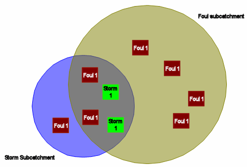
Figure 7 Storm and Foul Systems ATO
Again there are three options for the application of the uncoded areas and in all three options the ATO for the storm system has not changed. This is fundamental to Area Take Off with overlapping subcatchments and different system types.
Whether or not a subcatchment is overlapping another subcatchment has no effect on the ATO for that subcatchment.
If the 'Proportional System Type Split' option is selected, then for the storm system, still 40% of the 1.5 uncoded hectares is applied. For the foul system there is 2.2 hectares of uncoded area. There is a 75/25 split on coded areas in favour of the foul system and therefore 75% of the uncoded areas applies to the foul system. Therefore 1.65 hectares will be applied. The application of areas in this option are presented in Table 5a below.
|
System Type |
Total Area (ha) |
Contributing Area (ha) |
Runoff Area 1 |
Runoff Area 2 |
Other Runoff Area |
|---|---|---|---|---|---|
|
Storm |
2 |
0.8 |
0.2 |
0 |
0.6 |
|
Foul |
3 |
2.25 |
0.6 |
0 |
1.65 |
Table 5a Uncoded Areas Split in Proportion
If the 'Proportional System Type Split' option is not selected then all of the uncoded areas are applied to either the storm of foul systems. If the storm system is chosen, then the 2.2 hectares of uncoded area is not applied to the foul system as shown in Table 5b below, if the foul system is chosen then the areas are as shown in Table 5c below.
|
System Type |
Total Area (ha) |
Contributing Area (ha) |
Runoff Area 1 |
Runoff Area 2 |
Other Runoff Area |
|---|---|---|---|---|---|
|
Storm |
2 |
1.7 |
0.2 |
0 |
1.5 |
|
Foul |
3 |
0.6 |
0.6 |
0 |
0 |
Table 5b Uncoded Areas All Applied to Storm System
|
System Type |
Total Area (ha) |
Contributing Area (ha) |
Runoff Area 1 |
Runoff Area 2 |
Other Runoff Area |
|---|---|---|---|---|---|
|
Storm |
2 |
0.2 |
0.2 |
0 |
0 |
|
Foul |
3 |
2.8 |
0.6 |
0 |
2.2 |
Table 5c Uncoded Areas All Applied to Foul System
5. Common Pitfalls in Preparing IAS Data
InfoWorks ICM supports most unusual shapes, including self- intersecting shapes and multipart polygons and calculates their areas correctly.
A self intersecting polygon touches or intersects itself. All areas are now considered.

Figure 8 Self Intersecting Polygons
It is important to recognise that these shapes do not exist in reality and therefore InfoWorks ICM is only making the best possible approximation.
Multi-Part Polygons are polygons that have more than one boundary. For example a hole has an external boundary and internal boundary.
Examples:
a) Holes within IAS layer
b) Polygon within polygon (a hole if infilling polygon is removed)
c) Separate polygons combined as one or created multi-parts
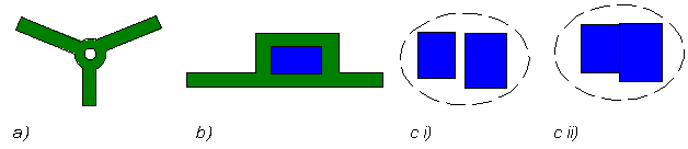
Figure 9 Multi Part Polygons
Although InfoWorks ICM can make a reasonable assumption of how to interpret most shapes, there is still some IAS which cannot be imported. There are five main types of mistake in preparing IAS data, which are described in the sections below.
- Missing or invalid data
- Unusual shapes
- Overlapping areas (optional)
- Too few vertices
- Intersection failure
The recommended method of 'cleaning up' problematic IAS data is to generate polygons within InfoWorks ICM, as described in Appendix A.
5.1 Missing or invalid data
The following messages in the ATO log indicate that data is missing or invalid:
WARNING: Subcatchment ID Ignored as no #G set for contributing area
Within the Sub-catchment grid only the subcatchments that have a #G flag are updated in the Area Take Off process. All subcatchments that are without a #G flag are reported with this warning.
ERROR: Feature not loaded.
Occurs if the IAS layer is unavailable/read only (for example currently being edited within another package)
ERROR: Invalid SYSTEM field value (id, value): (“Id:UniqueID”, “Text”)
ERROR: Invalid SURFACE field value (id, value): (“Id:UniqueID”, “Text”)
ERROR: Invalid STATUS field value (id, value): (“Id:UniqueID”, “Text”)
The input data has not been recognised. The Unique ID for the polygon and the text that has not been recognised are quoted. Any polygon that has an unrecognised code is ignored.
5.2 Unusual shapes
It is important to investigate errors where shapes are not loaded or warnings where areas are ignored.
These error messages recognise objects that cannot be correctly represented and are therefore not included within the Area Take Off calculations, such as an unrecognised object, a single point or a line.
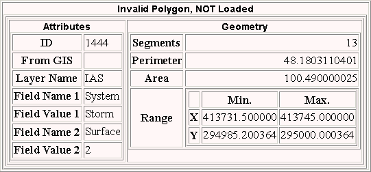
Figure 10 Invalid Polygon Report
The ID either refers to the polygon ID or the row ID of the GIS data source. The x and y Min and Max range provide the geographic co-ordinates to help further identify where the problem shape occurs. These polygons will simply need to be edited.
5.3 Overlapping Areas
WARNING: Id UniqueID and Id UniqueID overlap by Area will use Id:UniqueID
If requested overlapping areas may be reported within the log. The log will report the unique Ids of the overlapping polygons or subcatchments, the area of overlap and to where the overlapping area is applied.
InfoWorks ICM makes assumptions about overlapping subcatchments and polygons, as described in the sections below.
5.3.1 Overlapping Subcatchments
If two or more subcatchments overlap and a polygon exists on the overlap, provided the relevant system and surface codes apply, the polygon area will be applied to all subcatchments, as shown in Figure 12 below.
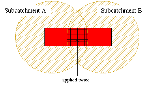
Figure 12 Overlapping subcatchments
5.3.2 Overlapping Polygons
For IAS data with the same System Type & same Surface Code, the two areas are merged, as shown below.
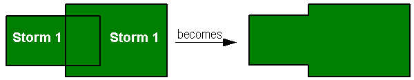
Figure 13a Polygons of the same System and Surface
For IAS data with different System Types but the same Surface Code, the overlap is ignored for one of the systems. The one that is retained depends on this order of priority: storm, foul, combined, unknown.
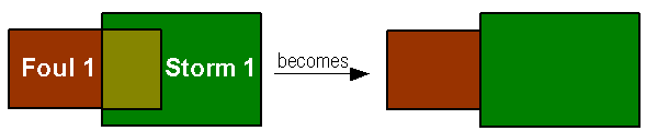
Figure 13b Polygons of the same Surface
For IAS data with different System Types and different Surface Codes, the lowest surface code takes priority (soak aways are considered 0, therefore highest priority.)

Figure 13c Polygons of different System and Surface
5.4 Intersection failure
ERROR: Intersection Failed.
If this error message occurs it is important to eliminate all errors that occur prior to failure (often the cause of this failure is already reported). If all error messages have been eliminated and intersection still fails send the IAS layer and Subcatchment data to support@innovyze.com
Appendices
A. Generate Polygons via Intersection
This process allows polygons generated in a GIS, to be imported into InfoWorks ICM. This is a very useful half way step because it allows a visual check on how problematic or unusual shapes are being interpreted. Generating polygons via intersections enables overlapping areas to be resolved, the cleaning of data and the option to intersect more than 1 GIS file or network object. It is particularly important for multipart shapes to be imported via this process.
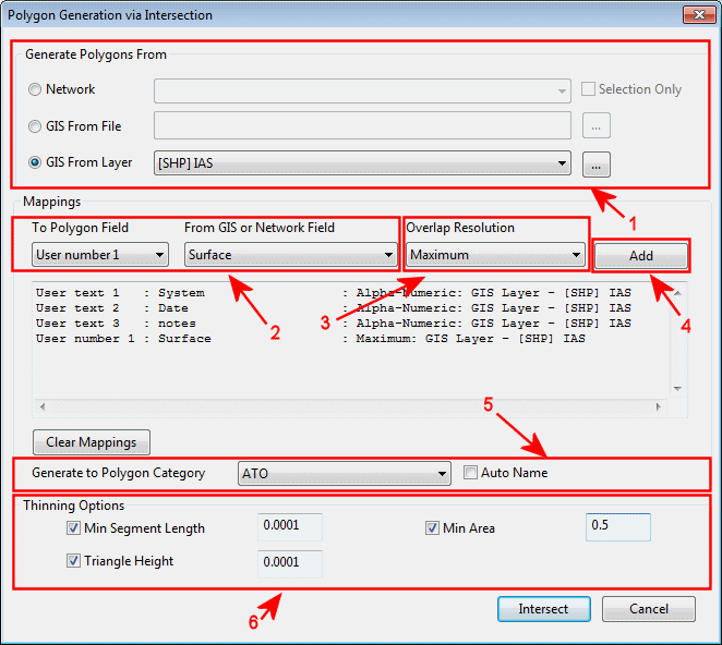
Figure A.1. Intersection Dialog
The following bullet points describe the items identified in the intersection dialogue above.
- The first step is to choose the source from which to generate your polygons from. The source may be a GIS file, a layer or a network subcatchment or polygon
- Choose the polygon user text or user polygon fields to be populated and match this to the field from the source data that shall be copied across.
- From overlap resolution drop down list choose which field value is to be used in cases where overlaps occur. The diagram below shows the different options available for the User number and user text fields.
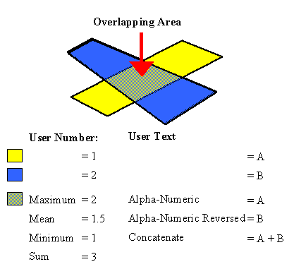
Figure A.2. Overlap Resolution Options
- In order to intersect chosen source a mapping must be Added, when a field is mapped the information is shown in the mapping list box below.
- Polygons need to be associated to a polygon category. Either select a predefined category or auto name categories. Auto name generates categories OVERLAP_X, where X is the number of overlaps in data from which the polygon is generated.
- Applying thinning criteria to the data may clean the polygon data to improve performance time and reduce unusual shape errors.
Min Segment Length:
The Minimum Segment Length is the distance between vertices in map unit length (m or ft).
Vertices at a distance less than the Minimum Segment Length from another vertex will not be included in generated polygons.
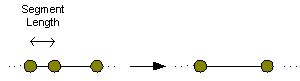
Figure A.3. Segment Length
Triangle Height
Minimum Triangle Height when generating polygons.
Vertices forming a triangle height less than the Triangle Height specified will not be included in generated polygons.
![]()
Figure A.4. Triangle Height
Multiple layers Intersected:
To enable multiple layers to be intersected, select an additional source and add at least one attribute from this source.
A GIS layer may be intersected by a polygon that may represent the model area or the network subcatchment.
For example intersecting an IAS layer with Subcatchments:
After assigning the IAS data above change the source type to Network and select Subcatchment. Map an unused user text field to the Subcatchment ID and select ADD.

Figure A.5. Intersection of Polygons and Subcatchments
Ensure there are no null fields in any relevant column of the IAS data. To check this, conduct an SQL for null fields in the InfoWorks ICM polygon field you have mapped the IAS data to. Delete any of these null fields.

Figure A.6. SQL to Identify Null Fields
Import of Multipart Shapes
Multi-Part Polygons are polygons that have more than one boundary. For example a hole has an external boundary and internal boundary (see Figure 9 for examples of multi part polygons.) By importing these polygons via intersection the correct areas of these polygons are retained.
How to Identify Invalid IAS Data
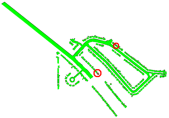
Figure A.7. Invalid IAS Areas Identified.
By filling the polygons a different colour to your back ground map you will be easily be able to identify any unusual shape polygons that have failed to import.
The quickest solution is likely to redraw these polygons within InfoWorks ICM or re-import using stricter thinning options or these polygons can be altered in a GIS package. Error messages in the log will also help identify the location of these errors
B. Relevant MapInfo Routines
To add the unique ID to a MapInfo layer
- Open the table.
- From the table menu select – Maintenance – Table Structure
- Select Add Field
- Name the field
- Click OK
- From the Table menu select column update
- Choose the table and your new column
- Type in value: rowid
- Click OK
Article © Innovyze 2012