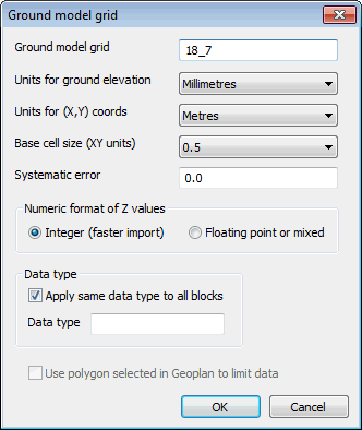
Ground Model (Grid) Import dialog
This dialog is used as part of the import process for gridded ground models. The dialog is displayed when you select one or more ground model files in the Windows File dialog and click Open.
You can import gridded ground model files in several different formats:
- ESRI format (.ASC)
- Vertical Mapper format (.TXT)
| Field | Description |
|---|---|
|
Ground Model Grid |
Enter the name of the Gridded Ground Model in this field. |
|
Units for ground elevation |
Select the units used in the files for the Z values you are about to import |
|
Units for (X, Y) coords |
Select the units used in the files for the X and Y coordinates you are about to import |
|
Base cell size (XY units) |
The Base cell size is calculated based on the highest resolution available in the imported data. Resolution can be increased by selecting a smaller cell size from the dropdown list if available. |
|
Systematic error |
The elevation offset. Correction of Z values will be applied on import. For example, if a systematic error of -2 is entered, Z values will be increased by 2 on import. |
|
Numeric format of Z values |
Select the Integer (faster import) option to import all Z values as integers. Select the Floating point or mixed option to include decimal places in the import of Z values. |
|
Data type |
Data Type can be used to add information about the source of the ground model data to the ground model, e.g. LIDAR. A Ground Model Theme on data type can subsequently be applied to the GeoPlan Window. Check the Apply same data type to all blocks box and type in data type information. The entered data type will be applied to all files imported. |
|
Use polygon selected in GeoPlan to limit data |
This option is available if there is a single polygon selected in the current GeoPlan Window. Check this option to limit the import of files to those files containing data that overlaps the selected polygon. |

