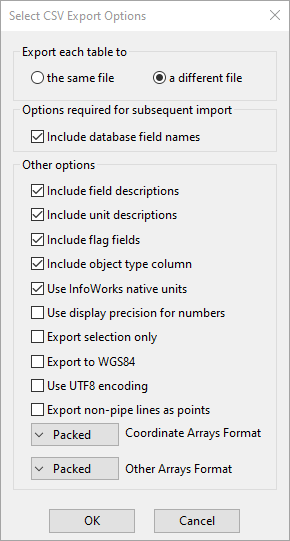
Select CSV Export Options dialog
This dialog allows you to select the options when exporting data to CSV filesComma Separated Variable file format is a standard file format that can be imported and exported by many software packages. Many types of data can be imported and exported using csv format by InfoWorks..
The dialog is opened, for example, by right-clicking a network in the Model Group window and selecting Export | To CSV.
Not every option is available on all instances of the dialog.
| Item | Description | |||||
|---|---|---|---|---|---|---|
|
Export each table to |
|
|||||
| Options required for subsequent import |
|
|||||
|
Include field descriptions |
Additional information useful when viewing the data outside InfoWorks WS Pro. |
|||||
|
Include unit descriptions |
Additional information useful when viewing the data outside InfoWorks WS Pro. |
|||||
|
Include flag fields |
Will increase the size of your CSV files. Only check this box if you need the flag data. |
|||||
|
Include object type column |
Additional field containing database Table Name information. |
|||||
|
Use InfoWorks native units |
We recommend that you check this if you intend to re-use the data in InfoWorks WS Pro. Any changes made by a user to the units used in the InfoWorks WS Pro interface (User Units) are only stored locally for that user. |
|||||
|
Use display precision for numbers |
Storage precision for some numbers is greater than display precision. For example, numbers stored as doubles have 15 decimal places. No numbers are displayed at this precision. Leaving this option unchecked may increase the size of your files |
|||||
|
Export selection only |
For this option you need to have the network open, and one or more network objects selected. Only the selected objects will be exported. |
|||||
| Export to WGS84 | If checked, coordinates will be exported using the WGS 84 geodetic system. This is for use in systems that require the WGS 84 geodetic system. | |||||
| Use UTF8 encoding | Select this option to encode the exported data using the UTF-8 encoding system. | |||||
| Export non-pipe lines as points |
If checked, objects that are represented as lines will be represented as points in the export data. This is so that they can be used in models that require all assets to be represented as points. The objects that are converted from lines to points are pump stations, valves, float valves, non return valves, and meters. |
|||||
|
Coordinate Arrays Format |
Including this data may greatly increase the size of your CSV files, so think carefully whether you need this data. If you want to re-create the network elsewhere, or re-import, failing to export arrays will cause loss of data. There are three options for export of coordinate data:
|
|||||
|
Other Arrays Format |
Including this data may greatly increase the size of your CSV files, so think carefully whether you need this data. If you want to re-create the network elsewhere, or re-import, failing to export arrays will cause loss of data. There are three options for export of array data other than coordinate data:
|

