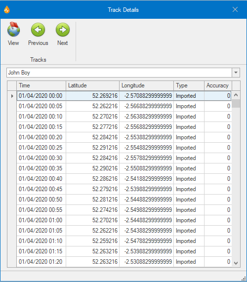
Track Details dialog

This dialog allows you to view the details of a user track and find tracking points on the map.

The dialog is displayed by selecting Track Details from the GPS group of the Map tab.

ClosedShow image

Item

Description

Tracks (ribbon group)

View

View

Centres the map on the tracking point selected in the list below.

Previous

Previous

Moves to the previous tracking point in the list.

Next

Next

Moves to the next tracking point in the list.
User track name A dropdown list for selecting the user track whose details you want to view.
List of tracking points

A list of the points within the user track that was selected from the dropdown list above.

Selecting a row in this list will highlight the point on the map with a red ring.

Double-clicking on a row will centre the map on that point, changing the zoom scale.

Time The time stamp of the tracking point. The interval reflects the value set in the GPS section of the Application dialog.
Latitude The position of the user or device for this tracking point.
Longitude
Type

Imported - The tracking point has been imported from a file. The tracking point is shown on the map as a small light grey circle.

System - The tracking point has been set by your Windows device. The tracking point is shown on the map as a small dark grey circle.

GPS - The tracking point has been set by a physical device. The tracking point is shown on the map as a small black circle.

Accuracy

Not applicable to imported tracking points and therefore shown as 0.

For system tracking points, shown in metres.

For GPS tracking points, shown as an HDOP value (1 to 20, where 1 is ideal and 20 is poor).

Layers and maps