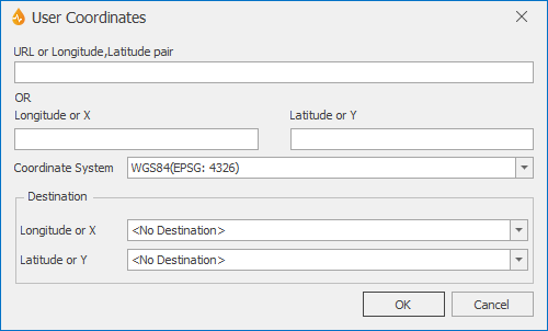
User Coordinates dialog
This dialog allows users without a tethered GPS device to enter coordinates manually or using a URL, and then convert them automatically to the default map projection system defined for the application in InfoAsset Mobile (see Application dialog).
The converted values will be automatically inserted into the specified fields of the current report.
The dialog is displayed when Enter Coordinates is selected from the Map group of the Report tab on the report generator.
| Option | Description |
|---|---|
|
URL or Longitude, Latitude pair OR Longitude or X Latitude or Y |
Coordinates obtained from an independent GPS device or URL of the coordinates from a web mapping service such as Google Maps. |
|
Coordinate system |
Coordinate system the coordinates come in:
|
|
Destination |
Destination dropdown box. X :destination field on the form / report the X coordinate value is to be copied to. Y : destination field on the form / report the Y coordinate value is to be copied to. If a report containing X/Y coordinates fields is open, these fields will automatically appear in the X and Y boxes. If the open report has no X and Y coordinate fields, <no destination> will be shown but you can select other destination fields on the report (any text fields present in the report will be available for selection from the two dropdown boxes). |
|
OK |
Makes the conversion and closes the dialog. |
|
Cancel |
Cancels the conversion process. |

