Ground Model Height Correction
The height correction tool allows adjustment of the heights of regions, or zones of a Ground Model. This functionality may be used to correct for road channel and kerb depths for example.
The zones to be adjusted are defined by Polygons. A selection of Nodes may be used as control points against which the ground model data is compared to calculate an average height error for each zone. Alternatively, a user defined height correction may be applied.
To carry out height correction on a Ground Model:
- In a checked out network, define regions of the ground model to be height adjusted by creating Polygons. Save the polygons in a Selection List.
- Optionally, create a Selection List of the Nodes to be used as control points.
- Right click on the ground model to be adjusted in the Explorer Window and select Height correct from the popup menu. This will display the Ground Model Height Correction dialog.
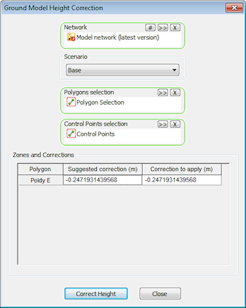
- In the Ground Model Height Correction dialog select Network and Polygons defined in Step 1.
- Select Control Points defined in Step 2 or enter a user defined height correction value:
- Control Points: for each defined zone the height of each control point is compared with the inferred ground model height at the XY of the control point. The height errors calculated for the control points in a zone are averaged to calculate a suggested correction, which is displayed in the Zones and Corrections table
- User Defined Value: enter a value in the Correction to apply column of the Zones and Corrections table
- Click the Correct Height button to carry out adjustment to the ground model using the value displayed in the Correction to apply column of the Zones and Corrections table.
- Select a location to which the height corrected ground model will be saved.
