Polygon Generation via Intersection
Subcatchments, existing polygons and polygons from GIS sources may be intersected to generate a new set of polygons. Polygons from a single source or from a number of different sources may be intersected.
The original polygons are divided so that each overlap area becomes a single separate polygon. (Note that the original polygons are not overwritten).
Thinning tools are available to enable you to clean the data allowing improvements in performance time and reducing the size of data generated.
The method of carrying out Polygon Generation via Intersection and the results produced are best demonstrated as an example:
Intersect Polygons Example
In this example, a network subcatchment and a GIS polygon representing a road overlap one another. Intersection is carried out, resulting in the creation of five new polygons.
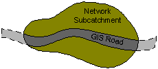
Overlapping Network Subcatchment and GIS Road Polygon
- Select Geometry | Polygon generation via intersection from the Model menu. This displays the Polygon Generation via Intersection Dialog.
- From the Polygon Generation via Intersection Dialog:
- To include the network subcatchment for polygon generation:
- Select the Subcatchment option from the Network dropdown list
- Select desired mapping options and click the Add button
- To include the GIS polygon for polygon generation:
- Browse for the GIS file containing the road polygon to populate the GIS From File field
- Select desired mapping options and click the Add button
- Select a polygon category option:
- Select an existing polygon category to which the newly generated polygons are to be associated
- Check the Auto Name box to name generated polygons according to number of overlaps of the original polygon sets.
- Select Thinning Options for the generated polygons as required. Cleaning the data can result in improved performance times and a significant reduction in data size.
- Click Intersect
or
Five new polygons are created:
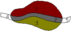
New Set of Polygons Created by Intersecting Polygons
Log
A log is produced including details of time taken for polygon creation and the number of vertices and edges created.
The Log will also show error messages and warning messages.
The log is saved temporarily in the Local Working Folder as an html file. When the log is closed in InfoWorks ICM, the log file in the Local Working Folder will be removed. To view the log at a later date, save the file in the Local Working Folder to another directory and/or under a different name.
