Polygon Generation via Intersection Dialog
The Polygon Generation via Intersection Dialog is used when generating polygons by intersecting subcatchments, existing polygons or GIS sources.
The dialog is displayed when Geometry | Polygon generation via intersection is selected from the Model menu.
Generate Polygons From
| Dialog Option | Description |
|---|---|
| Network |
Dropdown list of network objects that can be used for generating polygons. |
| GIS From File | Click  to display a standard File
Open dialog from which a GIS data source may be selected for use
in generating polygons. to display a standard File
Open dialog from which a GIS data source may be selected for use
in generating polygons. |
| GIS From Layer | Dropdown list of GIS layers for use in generating polygons. Click
to display the Layer Control dialog. |
Mapppings
| Dialog Option | Description | ||||||||
|---|---|---|---|---|---|---|---|---|---|
| To Field |
Dropdown list of Polygon User Text and User Number data fields. Values in the source data field selected from the From Field dropdown will be copied to the selected To Field of generated polygons. |
||||||||
| From Field | Dropdown list of data fields from the selected source data. Values in the data field selected in the From Field dropdown will be copied to the selected To Field of generated polygons. | ||||||||
| Overlap Resolution |
Dropdown list of options for deciding which From Field value is to be used in cases where overlaps occur. The choices differ depending on whether the selected To Field is a User Number or a User Text field. User Text
User NumberThe overlap options are:
A calculation is carried out on the From Field values of overlapping objects in accordance with the Overlap Resolution selected. The result of the calculation is copied to the To Field of the generated polygon. |
||||||||
| Mappings List |
List of all layers (network or GIS data source) to be used for generation of polygons. Data field mapping information is also displayed. Click the Add button to add a mapping to the list. Click the Clear Mappings button to remove all mappings from the list. |
||||||||
| Generate to Polygon Category |
Select an option for associating generated Polygons with a Polygon Category:
|
Thinning Options
| Dialog Option | Description |
|---|---|
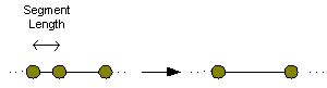
| Min Segment Length |
The Minimum Segment Length is the distance between vertices in map unit length (m or ft). Vertices at a distance less than the Minimum Segment Length from another vertex will not be included in generated polygons.
|
| Triangle Height |
Minimum Triangle Height when generating polygons. Vertices forming a triangle height less than the Triangle Height specified will not be included in generated polygons.
|
| Min Area |
Polygons of area less than the specified Minimum Area will not be generated. |