US SCS Model
The SCS method is a widely accepted model for predicting storm flow volumes from rural catchments. The method is used in the USA, France, Germany, Australia and parts of Africa. It was derived for rural catchments with uniform conditions. Although some engineers have used it on urban catchments, this is not its correct application. It can be used for rural catchments contributing to an urban system. Another model should be used for the urban areas.
This is a simple runoff model that allows for variation in the runoff coefficient depending on the catchment wetness. The wetness is updated during the storm and the runoff coefficient increases as the catchment wetness increases. The catchment response is described by the following parameters:
- Storage depth: the loss of rainfall that would occur in an infinitely large rainstorm, and to which losses tend as the storm continues.
- Catchment wetness index: used to modify the storage depth for dry or wet conditions.
- Initial abstraction factor: used to determine initial losses
Using the SCS Model
To use the SCS Runoff Volume Model, set the Runoff volume type field of the Runoff Surface to SCS (storage depth defined in the runoff surface) or CN (storage depth determined from subcatchment Curve number).
Wetness Index
The SCS catchment wetness index is defined in the initial conditions of the Rainfall Event. It is possible to define three classes of catchment wetness: dry, average and wet.
Storage Depth
The Storage Depth is entered in the SCS depth field of the Runoff Surface. The specified storage depth will be adjusted according to the wetness index (AMC) Hawkins R.H. et al (1985):
|
Catchment wetness |
Wetness index |
Change to storage depth |
|---|---|---|
|
Dry |
1 |
Multiplied by 2.281 |
|
Average |
2 |
- |
|
Wet |
3 |
Multiplied by 0.427 |
Curve Number
The storage depth is related to an index known as the runoff curve number (CN) representing the combined influence of soil type, land management practices, vegetation cover, urban development and antecedent moisture conditions on hydrological response. CN varies between 0 and 100, 0 giving no runoff and 100 giving 100 per cent runoff.
If the curve number (CN) for a surface is known, then S (in millimetres) can be derived using the following relationship:
|
|
|
To use curve numbers to determine storage depth, set the Runoff volume type of the runoff surface to CN and specify CN values for the subcatchment in the Curve number field of the subcatchment.
CN values for different conditions are available from various sources. See the Setting Runoff Coefficients from GIS Data topic for further details.
Initial Losses
The initial abstraction factor is entered in the Initial Abstraction Factor field of the Runoff Surface when the Initial Loss Type is set to SCS. Initial abstraction is calculated as:
|
|
where: 0 < k £0.2 |
See Equations below for further details.
Equations
The basis of the method is the continuity equation:
|
|
where: Iais the initial abstractions (initial losses) (mm) F is the cumulative actual retention (mm) Q is the total runoff (mm) P is the total rainfall (mm) Source: U.S.A. Bureau of Agriculture |
together with a relationship between rainfall, runoff and actual retention of the form:
|
|
where: S is the maximum potential retention (storage) (mm) |

These equations combine to give the SCS model:
|
|
for P ³Ia |
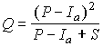
Within the Wallingford Procedure it is assumed that S does not include Ia.
The form of this model has been adapted within the Wallingford Procedure to be suitable for continuous simulation. The differential form of Equation 3 is given as:
|
|
|
Numerical representation of the derivative terms leads to:
|
|
where: q is the runoff over time interval (mm) p is the rainfall in time interval (mm) |
This equation is used incrementally within the software enabling the runoff coefficient (q/p) to change during the event.
The two parameters S and Ia are related by:
|
|
where: 0 < k £0.2 |
The original SCS approach recommended k=0.2. However other studies suggest k values between 0.05 and 0.1 may be more appropriate. Within the software a value of 0.1 S is included; however, this can be readily overridden by the software by specifying directly the Iavalue (set the Inital Loss Type to Abs (absolute) rather than SCS, and then specify the value for the initial loss in the Initial Loss Value field).
