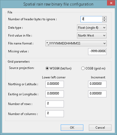
Spatial Rain Raw Binary File Configuration Dialog
This dialog is used to specify or update file information and grid parameters for forecast or observed data which is in a raw binary file format. It is displayed when you click Geometry in the Spatial time series database configuration dialog.Dialog options
| Option | Description |
|---|---|
| Number of header bytes to ignore |
Number of bytes at the top of the file which should be ignored. Up to 100 bytes can be ignored. Default is 0. |
| Data type |
Choose one of the following the data types from the dropdown list:
|
| First value in file |
Choose the location of the first row the grid from the dropdown list:
The data increments from west to east (left to right). |
|
File name format |
Choose the time format, which is encoded in the file name, from the dropdown list. |
| Missing value |
The number used to denote missing values in the data file. The default for any missing values is -9999.00000. 
Note
A number must be included in the file for every grid location. |
|
Source projection |
Set the source projection for the data to either WSG84 (lat/lon) [a latitude, longitude based on WSG84 datum] or OSGB (grid m) [a metric OSGB grid]. |
|
Northing or Latitude & Easting or Longitude (Lower left corner) |
The exact coordinates at the centre of the lower left corner cell. If the source projection is WSG84 (lat/lon), then the coordinates are specified in degrees. If the projection is set to OSGB (grid m), then the coordinates are specified in meters. |
| Latitude & Longitude (Increment) | The incremental increase to the centre of the next cell. |
| Number of Rows | The number of rows in the grid. |
| Number of Columns |
The number of columns in the grid. |
|
OK |
Commit the changes and close the dialog. |
|
Cancel |
Abort the operation and close the dialog. |

