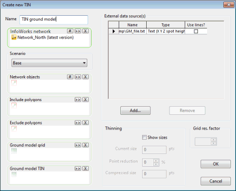
Create New TIN Ground Model Dialog
This dialog is used when creating a TIN ground model from other data.
It is displayed when you right-click on a Model group and choose New InfoWorks | Ground model TIN
Dialog description
| Item | Description |
|---|---|
| Name | Name of the TIN ground model to be created. |
|
InfoWorks network SWMM network |
Used when creating a TIN ground model in conjunction with Scenario and:
A box in which the relevant type of network, that includes the selected objects, can be dropped. The title of the box is determined by which option (New InfoWorks | Ground model TIN or New SWMM | Ground model TIN ) the dialog is invoked from. |
| Scenario |
Dropdown list of scenarios available for the selected InfoWorks network or SWMM network. Select the scenario containing objects in Network Objects and Include polygons / Exclude polygons selection lists. |
| Network objects |
Used to include a selection of network objects in an InfoWorks or a SWMM network, and for InfoWorks networks only; general points, cross section lines, bank lines and river reaches when creating a TIN ground model. Elevation data of selected points, lines and / or river reach section and bank profiles will be used to create new TIN vertices. Lines and sections will be treated as break lines during the creation process. |
| Include polygons |
Used in conjunction with the InfoWorks network or SWMM network to define areas to be included when creating a TIN ground model. Only points within the general polygons defined in the selected network will be used when creating the new TIN. The polygon defines the ground model boundary. |
| Exclude polygons |
Used in conjunction with the InfoWorks network or SWMM network to define areas to be excluded when creating a TIN ground model. Points within the general polygons defined in the selected network will not be used when creating the new TIN. |
| Ground Model Grid |
Used when creating a TIN Ground Model from an existing Grid Ground Model. Existing ground model from which new TIN is to be created. |
| Ground Model TIN |
Used when creating a TIN Ground Model from an existing TIN. Existing ground model from which new TIN is to be created. |
| External data source(s) |
Used when creating a TIN Ground Model from external data. Name - path of external data file Type - type of external data file Use lines? - enforce polylines as TIN edges |
| Thinning |
Used when Thinning a TIN Ground Model. Check the Show sizes box to enable the thinning options. Current Size - displays the number of points contained in the existing ground model Point Reduction - adjust percentage to set how much smaller the new ground model will be Compressed Size. - an estimate of the number of points in the new ground model |
| Grid res. factor |
Used when converting a Grid Ground Model to a TIN The grid resolution factor is used to lower the resolution of the TIN ground model, where the Grid Res. Factor x Grid Base Cell size corresponds to the minimum size to be considered when importing values from the Grid ground model. |
See Creating a TIN Ground Model for further information.
