GIS Export Dialog
This dialog is used when exporting networks

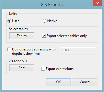
Dialog description
| Item | Description |
|---|---|
| Export Flags |
Displayed when exporting networks only. Check this option to export flag data. |
| Use ArcGIS 10 compatibility |
SHP file export only If checked, a direction check on polygons is performed to ensure that all exported single-part polygons are specified anti-clockwise. (Various features in ArcGIS 10 require single-part polygons to be specified anti-clockwise.) |
| Skip Empty Tables |
Geodatabase only If checked, empty tables will be excluded from export. |
| Units | Export using InfoWorks ICM Native Units / current User Units |
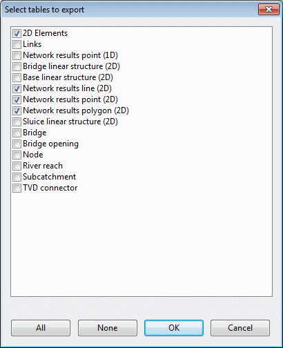
| Select tables |
If checked, export is restricted to a selection of tables. The tables to be exported can be selected when you click Tables. This displays the Select tables to export dialog. Check the boxes next to the tables to be exported. Use the All and None buttons to select or deselect all tables in the list. |
|
Do not export 2d results with depths below |
InfoWorks networks only. Displayed when exporting results only. Restrict the export of 2D mesh elements to those with depth greater than or equal to the value specified. |
| 2D zone SQL |
Displayed when exporting results only. InfoWorks networks only. Check the Export expressions option to include export of SQL expressions for 2D zone mesh elements. To create and edit SQL expressions for export, click Edit to display the Edit Expressions dialog. |
| Feature dataset |
Geodatabase only The name entered here will be used as a prefix for feature classes. |
| Configuration keyword |
Geodatabase only |
| MXD File | Geodatabase only
Check this option to export an MXD file to the path specified in the file box. (Not available when exporting maxima from multiple simulations) |