Geographical Adjustment of Selection Dialog
The location of a network object is specified by its X and Y co-ordinates, given in metres. This dialog allows you to change the location of the currently selected network objects by adjusting their co-ordinates. The dialog is displayed by selecting Selection operations | Geographically adjust selection option from the Selection menu located on the menu bar or by clicking an object on the GeoPlan and selecting the same option from the popup menu.
The upper half of the dialog adjusts the components’ X co-ordinates, the lower half adjusts their Y co-ordinates.
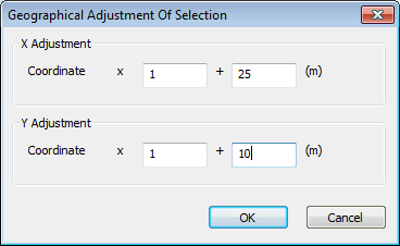
In each case, the entry in the box on the left changes the scale of the co-ordinates. For example, entering a value of 2 in the x box for the X adjustment doubles the X co-ordinate for all selected components. (The horizontal distance between components is therefore doubled but the vertical distance is unchanged.) Entries of less than 1 reduce the X co-ordinates, moving the components closer together.
The entry in the box on the right moves network objects relative to their current position. For example, entering a value of 100 in the + box for the Y adjustment moves all selected nodes 100 metres to the north of their original position. Negative entries move X co-ordinates west and Y co-ordinates south.
You can also adjust co-ordinates for individual network objects using the property sheets or by moving an object on the GeoPlan using the Edit Geometry ( ) button on the GeoPlan Tools toolbar.
