Integration with Google Earth
Introduction
An InfoWorks ICM network can be viewed as an overlay in Google™Earth, showing the objects' location on the aerial photography. It is possible to save the active network from the current GeoPlan Window as a KMZ file. See the Export to KMZ for Google Earth dialog topic for more details on how to create the KMZ file from within InfoWorks ICM and how to customise the export file.
The KMZ file can then be opened in Google™Earth. KMZ format is a compressed KML file and KML is the xml import/export format used for images by Google™Earth.
Inside Google Earth
Once this file has been created, open it in Google™Earth either by double clicking on the KML file icon in Windows Explorer or by going to the File | Open menu of Google™Earth.
 Tip
Tip The colours of the objects in Google ™Earth are those used in the current GeoPlan window. If a theme is active the colours from that theme will be used, otherwise the colours from the GeoPlan properties will be used.
The left hand sidebar (Places pane) of the Google™Earth main screen shows a list of all of the objects in the exported network. Folders can be expanded with the + signs to the left of their name. The check box is used to control the visibility of the objects in the folder (or the objects themselves when the folder is fully open). A dot means that some of the objects in a folder are visible; a tick is all of them, blank is none.
The objects which are initially shown on Google™Earth are determined by what has been made visible in your GeoPlan Window. Objects which are marked as invisible in the GeoPlan are present in the KML file but are initially hidden from view. To show these, check the checkbox by their name in the Places sidebar.
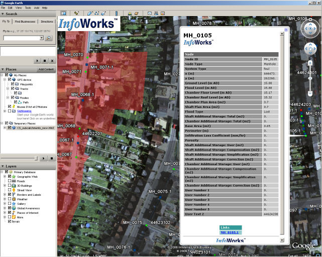
The Nodes are all clickable to reveal a balloon popup table of the node data. Each link has a smaller dot icon half way along, this can be clicked on to bring similar information for a link.
If the network has some results then the results for the node or link will be displayed on the "balloon" table when their icon is clicked.
If the network has subcatchments, the symbol check on the GeoPlan properties will switch on and off a line with arrow to the node it drains to. Please note that this does not apply to dummy subcatchment boundaries as these are centered on the nodes.