LandXML Surface Dialog
This dialog is used when:
- Creating a new a TIN ground model using LandXML formatted files as an external source
- Importing a TIN ground model from LandXML formatted files
It is automatically displayed when you select the relevant Land XML files to be created or imported.
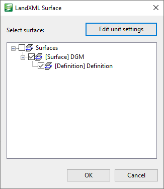
The dialog provides a tree view of the surface files that are included in the LandXML files which are being created/imported, and allows you to choose which surfaces you want to include in the ground model.
The following items are contained in the dialog:
| Field | Description |
|---|---|
| Edit unit settings |
Displays the LandXML Units dialog that can be used to specify the type of units to be used for the ground model. Note that the units in the selected LandXML files may be overwritten by your changes, and if no units are specified in a selected LandXML file, the default unit type of Metric and Meters for both linear and elevation values will be used unless you edit the unit settings. |
| Select surface |
A tree view of the surface files that are included in the LandXML files. Initially only the name of the surface at the top the file structure is shown. The + button located to the left of the surface name expands the view while the - button contracts it. A check box is included next to each surface. Adding a check in the box indicates that you want that surface to be included in the ground model. If the surface you select has other surface files below it, these are automatically selected. However, these can be de-selected by clicking on the box once more. |
| OK | Confirms the file selection and closes the window. All surface files with a check in the box next to their name will be included in the ground model. |
| Cancels | Cancels the operation and closes the window. |
See Creating a TIN Ground Model and Importing and Exporting TIN Ground Models for further information.
