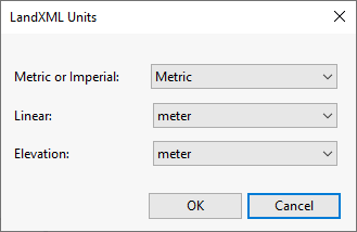
LandXML Units Dialog
This dialog is displayed when creating or importing a TIN ground model using LandXML formatted files. It is displayed by clicking on the Editing units setting button in the LandXML Surface dialog, and allows you to specify the units to be used by the ground model.
The items contained in the dialog are described below:
| Item | Description |
|---|---|
| Metric or Imperial |
The type of units to be used when importing or creating the TIN ground model. The unit type can be selected from the dropdown list. The default type is Metric. |
| Linear |
The facet of the selected Metric or Imperial units type that is to be used for linear values. The linear unit can be selected from the dropdown list. When Metric or Imperial is set to Metric, the default for Linear is set to meter. |
| Elevation |
The facet of the selected Metric or Imperial units type that is to be used for elevation values. The elevation unit can be selected from the dropdown list. When Metric or Imperial is set to Metric, the default for Elevation is set to meter. |
| OK |
Confirms the unit choices and closes the dialog. Note that the units in the LandXML files, which the ground model is being created/imported from, may be overwritten by these choices. |
| Cancel | Cancels the operation and closes the dialog. |

