New External Data Item Dialog
This dialog is used when creating a new TIN ground model from LandXML files, MapInfo MIF files, ESRI Shape files or text files.
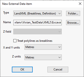
It is displayed when you click Add in the Create New TIN Ground Model dialog.
Dialog description
| Field | Description |
|---|---|
| Type |
A list of file types that the new ground model is to be created from. Choices are:
|
| Name | This field that is automatically populated when a file is selected using the Browse button. |
| Folder |
Displays a browser window enabling you to search for the folder that contains the files you want to create the new TIN ground model from. Only files that contain data of the selected type will be read and messages will be displayed informing you which ones these are. Messages will also be displayed for any file located in the folder that does not contain the type of data selected in the Type field. |
| Browse |
Displays a browser window enabling you to search for the file you want to create the new TIN ground model from. A message will be displayed informing you that the selected file is being read, and its name will be displayed in the Name field. A message will also be displayed if the selected file does not contain the type of data chosen in the Type field. |
| Treat polylines as breaklines | Determines whether or not polylines will be enforced as TIN edges. Unchecked (not enforced) by default. |
| X and Y units | A list of the type of units used for the X,Y points in the selected file. A scale factor may be applied depending on the type of unit selected. |
| Z units | A list of the type of units used for the Z points in the selected file. A scale factor may be applied depending on the type of unit selected. |
| OK | Confirms the file selection and closes the window. Note that this button is not enabled if the selected files do not contain data of the chosen type. |
| Cancels | Cancels the operation and closes the window. |
See Creating a TIN Ground Model for further information.
