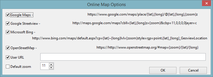
Online Map Options Dialog
The Online Map Options dialog is used to select the online maps that can be used to view the location of the GeoPlan. It is also possible to specify a user-defined URL.
The dialog is displayed when the Online Map Options button is clicked in the GeoPlan Page of the Options Dialog.
| Option | Description |
|---|---|
|
Google Maps |
Web mapping service application provided by Google™. |
|
Google Street View |
Technology featured in Google™Maps and Google™Earth that provides panoramic views from positions along many streets in the world. |
|
Microsoft Bing |
Web mapping service provided as a part of Microsoft™'s Bing suite of search engines. |
|
OpenStreetMap |
Collaborative project set up to create a free editable map of the world. |
|
User URL |
User-defined URL.  Tip Tip Please note that {long} {lat} and {zoom} must be specified in that order. See the example urls given for the built in online maps in the dialog itself. |
|
Default zoom |
Zoom in arbitrary units (0 to 20). To specify a zoom level for all web maps, check the adjacent check box and select a value. If this option is not enabled (i.e. unticked checkbox) the online map zoom level will match the GeoPlan current zoom level. |
|
OK |
Commit the changes and close the dialog. |
|
Cancel |
Abort the online map configuration. |
Select the desired web mapping services by ticking the check box adjacent to them.
These will appear as context menu options when the GeoPlan Window is right-clicked. See Viewing GeoPlan Locations and Objects on an Online Map for more information.

