Options - GeoPlan Page
The GeoPlan page on the Options dialog allows you to change a number of features that apply across the whole program. The dialog is displayed by selecting Options from the Tools menu.
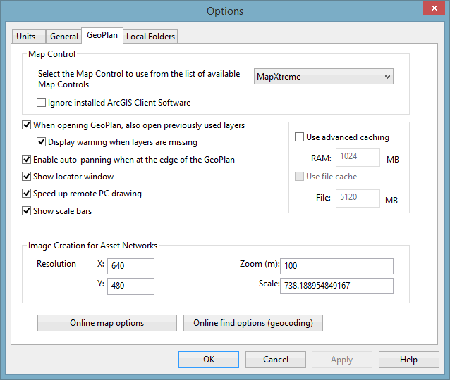
The options currently available on this tab are:
| Option | Description |
|---|---|
| Map Control |
Allows you to choose the map-display software. The dropdown lists the available map controls. Selecting a different map control changes the way in which the GeoPlan Window is displayed. See the Changing the current Map Control topic to know which map controls are supported in InfoWorks ICM.
|
| When opening GeoPlan, also open previously used layers | Check this box to automatically open GIS layers previously displayed on the Geoplan being opened. |
| Display warning when layers are missing | Check this box to have a warning message displayed if any previously used layers are missing. If the box is unchecked, missing layers will be ignored without warning. This option is only enabled when the option to open previously used layers is selected. |
| Enable auto-panning when at the edge of the GeoPlan | Check this box to turn on the Automatic Panning Tool. |
| Show locator window | Check this box to automatically show the GeoPlan Locator Map when a GeoPlan is opened. |
| Speed up remote PC drawing | Redrawing of the GeoPlan can slow down remote desktop sessions; select this option to improve performance by removing intermediate redraws during panning and zooming operations. |
| Show scale bars |
Check this box to display scale bars in the bottom left hand corner of the GeoPlan. (The GeoPlan must be closed and re-opened before changes to this option are applied.) |
| Use advanced caching | Check this box to use an advanced caching system to improve drawing performance by reducing unnecessary redraws. The most significant improvements will most likely be seen when replaying 2D results and viewing large networks. Transitional drawing effects may occur when using this option (e.g. blurred display, partly selected items); these effects will disappear when the GeoPlan has completed its drawing. The GeoPlan must be restarted for changes in this option to take effect. |
| Use file cache | Check this box to allow caching to the hard drive in order to improve drawing performance. (See Use advanced caching for further details). |
| Image Creation for Asset Networks | Enter values to set the resolution and zoom/scale values to be used when creating location sketch images for selected |
|
Online map options |
Displays the Online Map Options dialog, where the availability of web map service options on the GeoPlan context menu is controlled. See Online Map Options dialog and Integration with Web Mapping Software for further details. |
|
Online find options (geocoding) |
Displays the Online Find Options (Geocoding) dialog, where access to the web map applications, which are to be used to find a location, is specified. |
For information about alternative controls, contact Innovyze.
