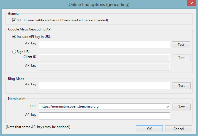
Online Find Options (Geocoding) Dialog
The Online Find Options (Geocoding) dialog is used to specify the web map applications that are to be used for geocoding (converting addresses into geographic coordinates) and reverse geocoding (using geographic coordinates to find a location, usually a postal address). In order to access these applications, a connection to the Internet is required and you may need to know the Application Programming Interface (API) key(s) supplied to your company from the relevant web map application provider(s).
The  (GeoPlan Find) and the
  (Go
To XY Coordinates) options, accessed from the toolbar
The dialog is displayed when the Online find options (geocoding) button is clicked in the GeoPlan Page of the Options dialog.
| Option | Description | ||||||
|---|---|---|---|---|---|---|---|
| SSL |
Select this box to indicate that InfoWorks ICM must check that Secure Sockets Layer (SSL) encryption certificate is valid. A valid certificate should indicate that access to the site is secure. |
||||||
|
Google Maps Geocoding API |
Access to the web map application provided by Google™ can be specified using either of the following options:
|
||||||
|
Bing Maps |
Access to the web map application provided as a part of Microsoft™'s Bing suite of search engines can be specified by entering the key supplied by Microsoft™ in the API key field. |
||||||
|
Nomination |
Access to a Nomination (a search engine for OpenStreetMap data) application provider is set up by specifying the following:
|
||||||
|
Test |
Test that the site can be accessed using the specified information, and the length of time (in seconds) taken to access the site. |
||||||
|
OK |
Commit the changes and close the dialog. |
||||||
|
Cancel |
Abort the geocoding configuration. |
Select the desired web map application to be used by completing the appropriate fields. Click Test to test that the connection is working and then click OK to save the changes.

