Allocate Land Use Demand to Nodes dialog

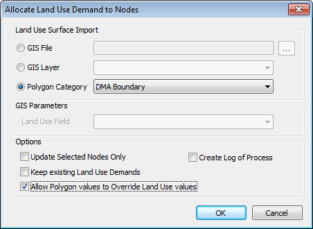
The Allocate Land Use Demand to Nodes dialog is used when carrying out automatic allocation of Land Use demands to the network. The dialog is displayed by selecting Node Polygons | Allocate Land Use Demand to Nodes from the Model menu. This allows automatic calculation of the contribution of land use area demands to nodes in the network using data imported from GIS.

See the Allocating Land Use Demand to Nodes topic for details.

ClosedShow image

Group Description

Land Use Surface Import

Select the source of the Land Use polygon data:

Option Description

GIS File

Enter the path of a GIS File or use the button to browse for a file.

GIS Layer

Select a layer from the dropdown list of layers open in the current GeoPlan.

Polygon Category

Select the Polygon Category option to use polygons that have already been imported or digitised in the network.

Select a polygon category from the dropdown list. Only polygons associated with the selected category will be considered as land use polygons during the allocation process.

GIS Parameters

If using GIS File or Layer source data, select the field containing the Land Use reference from the Land Use Field dropdown list.

Options

Option Description

Update Selected Nodes Only

Check the Update Selected Nodes Only box to restrict the update of land use demands to the currently selected nodes only. Land Use Demands will remain unchanged for the other nodes in the network.

Please Note

Note: If the Update Selected Nodes Only option is not checked, land use demand at all nodes in the network will be updated.

Keep existing Land Use Demands

Check the Keep existing Land Use Demands box to retain the Land Use demand already allocated to the nodes to be updated. Demands generated by the current allocation process will be added to the existing Land Use Demands.

IMPORTANT

If the Keep existing Land Use Demands option is not checked, land use demand at nodes to be updated will be overwritten.

Allow Polygon values to Override Land Use values

This option is only available when using Polygon objects in the network as the source of the Land Use polygon data.

Check the Allow Polygon values to Override Land Use values box to allow demand information specified at the Polygon (in the Number or Properties, Specific Consumption and Land Use Demand fields) to be used in preference to the demand information specified at the Land Use.

The ID of the Land Use polygon will be assigned to the node along with the Land Use demand and can be viewed in the Land Use tab of the Nodes Property sheet.

See Calculation of Land Use Demand at Nodes for further details.

Create Log of Process

Check the Create Log of Process box to display a summary log once the allocation process is complete.

The log is saved temporarily in the working folder as an html file. When the log is closed in InfoWorks, the log file in the working folder will be removed. To view the log at a later date, save the file in the working folder to another directory and/or under a different name.


Allocating Land Use Demand to Nodes

Setting the local folders locations