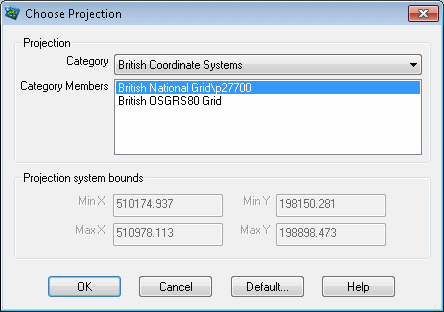
Choose Projection dialog
![]()

InfoWorks WS Pro has a default coordinate system that is used for all new networks. The co-ordinates entered for network objects are assumed to relate to this system unless you specify otherwise.
To change the coordinate system for an existing network:
- Select Set Coordinate System from the GeoPlan menu to display this dialog.
- InfoWorks WS Pro is supplied with a number of nationally-recognised coordinate systems. Choose the type of coordinate system from the Category box and the specific coordinate system from the Category Members box.
- If you want to set your own coordinate system, choose Non-Earth as the Category. You must then enter the projection system bounds (this section of the dialog is greyed out for all other coordinate systems). These are the ranges of coordinate values that will be covered by the GeoPlan window. All objects added to the network must have co-ordinates within these ranges. The maximum X and Y values must be larger than the minimum values, and all values must be greater than zero.
- If you want the selected system to become the default for all new networks, click the Default button and confirm that the coordinate system is to be used in future.
- Click OK to apply the new coordinate system.
After changing the coordinate system, the coordinate values that have been entered for any existing network objects will remain the same, so the position of these objects on the background map will change to reflect the new system. You may then need to move existing network objects.
Note that you can change the coordinate system as soon as you have created a network, before adding any objects.
