MapX Display Properties dialog
![]()

The MapX Display Properties dialog is used to change the properties of a specific MapX layer.
The dialog is displayed by clicking the Display button on the MapX Layer Control dialog.
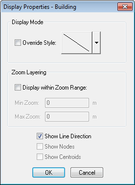
Use Display Mode to define how the objects in the layer are drawn.
Use Zoom Layering, if required, to set a range outside of which the layer is automatically hidden.
Zoom Layering
You may notice a discrepancy between the zoom values entered in the Zoom Layering section of the dialog and the zoom range within which the layer is visible on the GeoPlan. This discrepancy is due to the differing definitions of zoom between MapInfo and InfoWorks WS Pro.
MapInfo defines the zoom to be the window width, whereas InfoWorks WS Pro calculates the zoom of the GeoPlan to be the lesser of the window's width and height.
Typically GeoPlans are displayed with a greater width than height. Therefore the Zoom Layering values will be applied to the GeoPlan window height.
If the GeoPlan is displayed with height greater than width the InfoWorks WS Pro zoom and MapInfo zoom will coincide.
