Time Series Data Objects
There are two types of Time Series Data (TSD) objects in InfoAsset Manager: Scalar and Spatial. These objects provide an intermediate store between external data sources (such as SCADA/telemetry or RADAR) and an InfoAsset Manager run.
The main differences between the Scalar TSD and the Spatial TSD objects are shown in the table below.
|
Characteristic |
Scalar Time Series Data | Spatial Time Series Data |
|---|---|---|
|
Type of time varying data stored |
Scalar |
Spatial |
|
Information stored in each time series data point |
In a Scalar TSD, each time series data point has no geometry (i.e. no polygons) and has only one value. |
Each time series data point in a Spatial TSD stores a number of polygons and a value for each of these polygons. |
|
Number of datastreams and data sources |
Scalar TSDs can have many streams and data sources defined. |
Spatial TSDs can only contain one stream (and only one data source). Spatial data requires much more storage than scalar data so limiting spatial TSDs to one stream significantly helps partition the storage. Also, a model tends to have many scalar data sources (and only a few spatial data sources) so it is more manageable to keep a number of streams together in one Scalar TSD rather than have many tree objects. |
| Display in InfoAsset Manager |
Scalar values are displayed alongside their timestamp in a grid (see Time Series Data Grid). |
Spatial time series values are displayed in the GeoPlan as a theme. See Displaying Spatial Rainfall on the GeoPlan. |
For an in-depth description of these two objects, see the Scalar Time Series Data topic and the Spatial Time Series Data topic.
See the Working with Database Items topics for details on how to create, open, edit, save or delete Scalar and Spatial time series data objects.
The specific differences in the way time series data objects behave compared to the other database items are:
- To save a TSD, click
 located in the top right corner of the TSD and select Yes when prompted to confirm the save.
The procedure to view the time series data points for an individual stream inside a time series data depends on the TSD object type:
- Scalar time series data - drag a Scalar TSD object onto the InfoAsset Manager main window, select a row (stream), right-click and select Show time series data from the context menu.
- Spatial time series data - drag a Spatial TSD object onto the InfoAsset Manager main window.
The Time Series Data Grid, where the data points can be viewed and edited (if required), is opened.
 Tip
Tip If a Spatial TSD object that does not have its one and only stream configured (an empty Spatial TSD object) is dragged from the tree view onto the main window, the Spatial Time Series Data Configuration dialog will be displayed instead of the Time Series Data Grid.
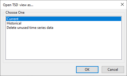
- Right-click the desired TSD object in the Explorer window to display the Open TSD view as dialog.
- Select Current.
- Click OK. The current view of the TSD is displayed (Observed or Forecast Page for Scalar TSD and Time Series Data Grid for Spatial TSD).

- Right-click the desired TSD object in the Explorer window to display the Open TSD view as dialog.
- Select Historical from the list.
- Click OK. The Select date for historical view of TSD dialog is displayed.
- Select the date and time to return to and click OK. The historical version of TSD corresponding to the date and time selected is displayed in read-only mode.

Historical data used in runs cannot be deleted.
- Right-click the desired TSD object in the Explorer Window to display the Open TSD view as dialog.
- Select Delete unused time series data from the list.
- Click OK. The Delete unused time series data dialog is displayed.
- Specify a date upper limit for data deletion. Only unused values with time stamps older than this date will be deleted.
- If required, enable the Keep the latest version of each value even if it has not been used by a simulation option. This means that InfoAsset Manager will not delete the latest version of every value ( = latest imported) with a time stamp older than the date specified in the Only delete data with time stamps older than field.
- Click OK to delete the historical data and close the dialog.

For forecasts, it is the time stamp of the forecast origin that is used, rather than the time stamped values of the forecast data. If a forecast origin is deleted all its values will be too.
An example is included in the Delete Unused Time Series Data Dialog topic.
You can edit data contained in time series data objects. See Editing Time Series Data for more information.
Time series data may be updated from external data sources. See Updating Time Series Data for further details.
