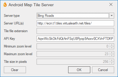
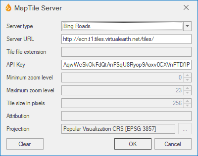
Map Tile Server dialog
This dialog (in two variants) is used to set the default background map tile server settings, including the tile server to be used to open internal Internet maps. For Android, internal maps use the Android OSMDROID component to get Internet tiles from specific servers.
The appropriate dialog is displayed when you select the ellipsis button from the Android Map Tile Server property or the Background Map Tile Server property in the Application dialog.
| Option | Description | ||||||||||||
|---|---|---|---|---|---|---|---|---|---|---|---|---|---|
| Server type |
The type of tile server to be used to open internal Internet maps.
|
||||||||||||
|
Server URL(s) / Server URL |
The server URL used to locate the tiles. For Android, this can be a | separated list. For example: http://a.tile.gisserver/|http://b.tile.gisserver/|http://c.tilegisserver/ For the User Defined server type, this should contain {LEVEL}, {ROW}, {COL} and optionally {QUADKEY}. For the WMTS server type, this should be the WMTS URL or the WMTS Service information separated by | in the format {Get Capabilities} | {Get Tile} | {Version (optional)}. Use {TileMatrix}. {TileRow} and {TileCol} where required in the Get Tile URL. |
||||||||||||
| Tile file extension |
Does not apply to Bing or WMTS map server types. The file extension used to indicate type of file. Default is png. |
||||||||||||
| API Key | The API key for use with the Bing and user defined map servers. | ||||||||||||
| Minimum zoom level |
Does not apply to Bing map server types. Specifies the minimum zoom level. Default is 0. |
||||||||||||
| Maximum zoom level |
Does not apply to Bing map server types. Specifies the maximum zoom level. Default is 23. |
||||||||||||
| Tile size in pixels |
Does not apply to Bing map server types. The size of a tile in pixels. Default is 256. |
||||||||||||
| Attribution |
Not available for Bing or WMTS map server types. Text entered here is used to put a text overlay on the bottom right of the map. This is normally required as an acknowledgement if you are using OpenMap source maps. |
||||||||||||
| Projection |
Does not apply to Bing map server types. Opens the Choose Coordinate System dialog. |
||||||||||||
| Clear | After confirmation, clears the specified server URL(s). | ||||||||||||
|
OK |
Saves any changes and closes the dialog. |
||||||||||||
|
Cancel |
Cancels the operation. |


