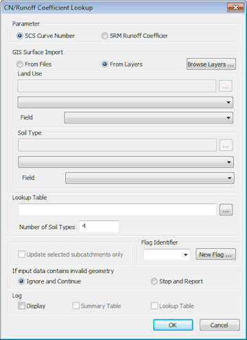
CN/Runoff Coefficient Lookup Dialog
The CN/Runoff Coefficient Lookup dialog is used as part of the process of generating SCS Runoff Curve Numbers or SRM Runoff Coefficients from GIS data on land use and soil type. The dialog is displayed when Subcatchment | CN/Runoff Coefficient Dialog lookup is selected from the Model menu.

The process requires two GIS files (land use and soil type), which can be loaded as GIS background layers, and a lookup table that relates these to Curve Number.
For further information, see the Setting Runoff Coefficients from GIS Data topic.
| Option | Description |
|---|---|
| Parameter |
Select the type of value to be set:
|
| GIS Surface Import |
Select the source of the Land Use and Soil Type data:
Use the Field dropdown to select the field in the GIS file that contains the Land Use/Soil Type data. |
| Lookup Table |
Enter the path of the csv format lookup table, or browse for the table using the Number of Soil Types - the total number of lookup columns (ignoring the Land Use values in column 1). |
| Update selected subcatchments only |
Check this option to set values for currently selected subcatchments only. If this option is unchecked, values will be set for all subcatchments in the network for which data is available. |
| Flag Identifier |
Flag to be applied to changed data. Select an existing flag from the dropdown list or click the New Flag button to display the User Defined Flags Dialog. |
| If input data contains invalid geometry |
Select option for action to carry out if GIS data contains invalid geometry:
|
| Log |
Set the log display options:
|
 button