NOAA ATLAS 14 Rainfall Generator
This generator is displayed when the NOAA ATLAS 14 Rainfall Generator button is selected from the Rainfall Generator dialog. It allows you to download, from the NOAA's Precipitation Frequency Data Server (PFDS), NOAA Atlas 14 precipitation frequency estimates for specified locations within the United States. It can be used to download new storm data as a zip file or to edit or delete an existing file, and to import downloaded data, extracted from the zip file, to the rainfall event in the Rainfall Generator dialog.
The NOAA ATLAS 14 generator consists of a menu bar that contains the following options:
- File - contains the following options:
- New - Generates a new storm. The NOAA Input Parameters Rainfall data page is displayed, allowing you to specify the required parameters for the NOAA storm to be generated.
- Open - Opens the storm, which is currently selected in the Current folder box, in the Rainfall data page, enabling you to view and edit the storm parameters.
- Close - Closes the current page without saving any changes.
- Exit - Saves any changes and closes the NOAA ATLAS 14 Rainfall Generator.
- Help - Displays the InfoWorks ICM help topics in a browser window.
And the following rainfall generator pages:
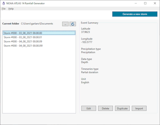
This page is initially displayed when the NOAA ATLAS 14 Rainfall Generator button is selected from the Rainfall Generator dialog.
The items contained in the main page of the dialog are described in the following table:
| Item | Description |
|---|---|
| Generate a new storm | Opens the Rainfall data page, allowing you to specify the required parameters for the NOAA storm to be generated. |
| Current folder |
Displays the name of the current folder. A list of NOAA storm zip files, located in the Current folder, are displayed in the list box. When a new storm is saved, the downloaded zip file is automatically saved to the currently selected folder. |

Browse |
Opens a Browser for folder window that allows you to select another folder or create a new one. The name of the new or selected folder will be displayed in the Current folder. |

Reload |
Reloads the existing NOAA storm zip files that are located in the Current folder and displays their names in the list box. |
| Event Summary |
Displays the following event summary data for the storm that is currently selected in the Current folder list box:
See the Rainfall data page for further information. |
| Edit |
Opens the Rainfall data page for the storm currently selected in the Current folder list box. |
| Delete |
Deletes the file currently selected in the Current folder list box. |
| Duplicate |
Creates a duplicate zip file for the storm currently selected in the Current folder list box. The duplicated file will have a ! appended to its name. |
| Import |
Unzips the applicable storm files for the storm currently selected in the Current folder list box, and imports the applicable rainfall data for each storm to the Storm grid in the NOAA Rainfall Generator dialog. |
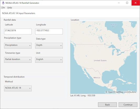
This page is displayed when you either click Generate a new storm or select the New option from the File menu in the Main page, and is used to specify the rainfall parameters for the storm.
The items contained in the Rainfall data page are described in the following table:
| Item | Description |
|---|---|
|
Latitude |
The latitude of a location for which storm data is to be downloaded. This can either be typed in or selected on the map displayed in the Location box. The specified Latitude and Longitude denote the centroid location for the storm data to be generated. |
| Longitude | The longitude of a location for which storm data is to be downloaded. This can either be typed in or selected on the map displayed in the Location box. The specified Latitude and Longitude denote the centroid location for the storm to be generated. |
| Precipitation type | The type of precipitation data (precipitation, i.e. all types or rainfall only) to be included in the generated storm. |
| Data type | The type of storm data (depth or intensity) to be included in the generated storm. |
| Timeseries type | The type of time series data (annual maximum or partial duration) to be included in the generated storm. |
| Unit | The type units (English or metric) to be used for the generated storm data. |
| Method |
The method for temporal distribution to be used for the generated storm data. Choose one of the following methods:
|
| Location |
The location for which storm data is to be downloaded can be selected by clicking on a position on the displayed map. If a location is selected on the map, its latitude is displayed in the Latitude field and its longitude in the Longitude field. Tip: The mouse scroll button can be used to zoom in or out on the map. |
| Back | Discards any changes and returns to the Main page. |
| Continue | Saves any changes, downloads the relevant data and displays the Temporal distribution page. |
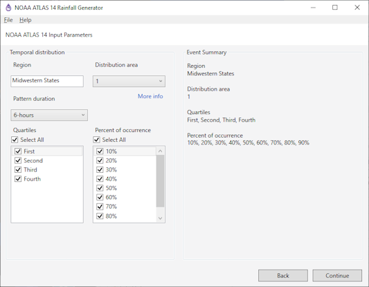
This page is displayed when you click Continue on the Rainfall data page, and have selected NOAA ATLAS 14, NRCS Regional, Huff Distribution or Bulletin 75 as the method of distribution. It is used to specify the temporal distribution parameters for the storm.
The items contained in the Temporal distribution page are described in the following table:
| Item | Description |
|---|---|
| Region |
If the Method for temporal distribution is set to NRCS Regional on the Rainfall data page, this is a dropdown list of temporal distribution regions from which the applicable one can be selected. If the Method for temporal distribution is set to NOAA ATLAS 14, this is a read-only field which displays the name of the region within which the specified Latitude and Longitude are located. |
| Pattern duration |
Displayed when the Method for temporal distribution is set to NOAA ATLAS 14 on the Rainfall data page. A dropdown of the durations for the temporal distribution. |
| Catchment area |
Displayed when the Method for temporal distribution is set to Huff Distribution or Bulletin 75 on the Rainfall data page. A dropdown of the size of the catchment area for which storm data is to be generated. |
| Distribution area |
Displayed when the Method for temporal distribution is set to NOAA ATLAS 14 on the Rainfall data page. A dropdown of the distribution area within the Region for which storm data is to be generated. |
| Distribution type |
Displayed when the Method for temporal distribution is set to NRCS Regional on the Rainfall data page. A dropdown of the distribution types within the selected Region which are to be used for generating the storm data. |
| Quartile |
Displayed when the Method for temporal distribution is set to NOAA ATLAS 14 on the Rainfall data page. A list of distribution quartiles. A check in a box indicates that data for that quartile is to be included in the storm data. Removing a check will exclude that quartile data from the storm. By default, the Select all box is checked and all quartiles are selected. De-selecting the Select all box removes the check from any quartile currently selected. Note: At least one quartile must be checked. |
| Percent of occurrence |
Displayed when the Method for temporal distribution is set to NOAA ATLAS 14 on the Rainfall data page. A list of occurrence percentages. A check in the box indicates that data for that percent of occurrence is to be included in the storm data. Removing a check will exclude any data for that occurrence from the storm. By default, the Select all box is checked and all occurrence percentages are selected. De-selecting the Select all box removes the check from any occurrence percentages currently selected. Note: At least one percent of occurrence must be checked. |
| More info |
Displayed when the Method for temporal distribution is set to NOAA ATLAS 14 on the Rainfall data page. A hyperlink that opens the Temporal Distributions page on the Hydrometeorological Design Studies Center website, where you can find further information about temporal distribution. |
| Event Summary |
Displays the following event summary data for the storm that is currently defined on this page. If the Method for temporal distribution is set to NOAA ATLAS 14 on the Rainfall data page, the following summary information is displayed:
If the Method for temporal distribution is set to NRCS Regional on the Rainfall data page, the following summary information will be displayed:
If the Method for temporal distribution is set to Huff Distribution or Bulletin 75 on the Rainfall data page, the following summary information will be displayed:
See the descriptions above for further information. |
| Back | Discards any changes and returns to the Rainfall data page. |
| Continue | Saves any changes, downloads the relevant data and displays the Event page. |
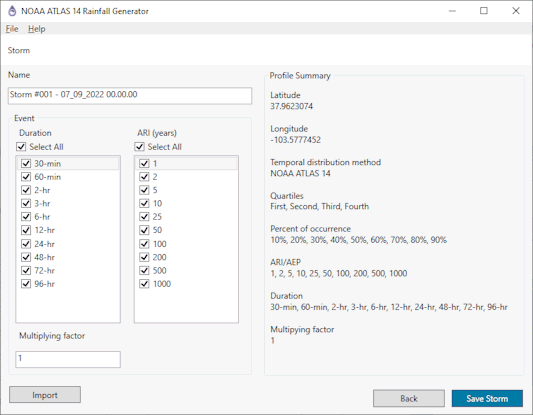
This page is displayed when you click Continue on the Temporal distribution page and is used to specify the name and event parameters for the storm. Or, if you have selected Alternating Block as the method of distribution, then this page is displayed when you click Continue on the Rainfall data page, and is used to specify the temporal distribution parameters for the storm.
This page is also used to save and import the relevant storm data.
The items contained in the Event page are described in the following table:
| Item | Description |
|---|---|
| Name |
A unique name for the storm. The downloaded data is saved to a zip file with the name specified in this field. A name is automatically generated using the format: |
| Time series interval |
Displayed when the Method for temporal distribution is set to Alternating Block on the Rainfall data page. The time series interval must be an integer that is divisible by 5. No decimals are allowed. |
| Time to peak |
Displayed when the Method for temporal distribution is set to Alternating Block on the Rainfall data page. The time to peak can be selected from the dropdown. The default is 50%. |
| Duration |
A list of storm durations in minutes, hours and days. A check in the box indicates that data for that duration is to be included in the storm data. Removing a check will exclude that duration from the storm. By default, the Select all box is checked and all durations are selected. De-selecting the Select all box removes the checks from any durations currently selected. Note: At least one duration must be checked. |
| ARI |
Displayed when Timeseries type is set to Partial duration on the on the Rainfall data page. A list of annual recurrence intervals (ARI) in years. A check in the box indicates that data for that ARI is to be included in the generated storm data. Removing a check will exclude that ARI from the storm. By default, the Select all box is checked and all ARIs are selected. De-selecting the Select all box removes the checks from any ARIs currently selected. Note: At least one ARI must be checked. |
| AEP |
Displayed when Timeseries type is set to Annual maximum on the Rainfall data page. A list of annual exceedance probabilities (AEP) in years. A check in the box indicates that data for that AEP is to be included in the generated storm data. Removing a check will exclude that AEP from the storm. By default, the Select all box is checked and all AEPs are selected. De-selecting the Select all box removes the checks from any AEPs currently selected. Note: At least one AEP must be checked. |
| Multiplying factor |
A multiplying factor that allows scenarios, such as a 10% increase in rainfall, to be investigated. |
| Profile Summary |
Displays the following profile summary:
If the Method for temporal distribution is set to NOAA ATLAS 14 on the Rainfall data page, the following information will also be included in the profile summary:
If the Method for temporal distribution is set to NRCS Regional on the Rainfall data page, the following information will also be included in the profile summary:
If the Method for temporal distribution is set to Huff Distribution or Bulletin 75 on the Rainfall data page, the following information will also be included in the profile summary:
If the Method for temporal distribution is set to Alternating Block on the Rainfall data page, the following information will also be included in the profile summary:
|
| Back | Discards any changes and returns to the Temporal distribution page. |
| Save storm | Saves the downloaded storm data to a zip file with the name specified in the Name field and displays the Main page. The file is automatically stored to the folder currently selected on the Main page, and the name of the storm will added to the Current folder list on the Main page. |
| Import storm |
Closes the NOAA Atlas 14 Rainfall Generator, unzips the downloaded file for this storm, and imports the relevant data for each storm to the Storm grid in the Rainfall Generator dialog. A file will not be saved to the folder currently selected on the Main page. |
See Generating NOAA Rainfall for information about how to use the NOAA ATLAS 14 rainfall generator to generate data for a NOAA design rainfall event.


