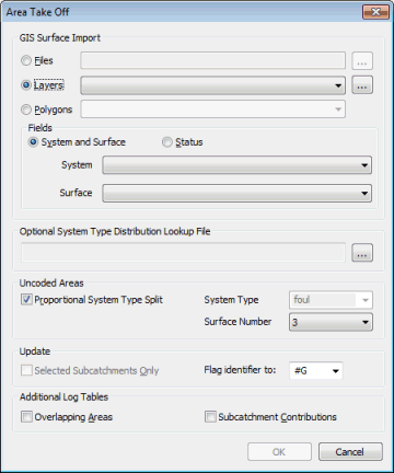
Area Take Off Dialog
This dialog is used when carrying out Area Take Off. The dialog is displayed by choosing Subcatchment | Area take off from the Model menu. This allows automatic calculation of runoff surface areas and the contributing areas of subcatchments using data imported from GIS.
Full details of the theory behind surface area take off can be found in the Area Take Off Technical Note.
GIS Surface Import
The Area Take Off Dialog allows the digitised GIS Impermeable Area Survey (IAS) data to be read by:
- Browsing for a GIS file:Click on the
 button to identify the table.
 - Selecting a Layer in the GeoPlan
View: Select from the dropdown list or click on the
 button to display the GIS Layer Control Dialog.
 - Selecting polygons imported from GIS: Select polygon Category field from dropdown.
Fields
The Fields dropdown lists are used to select the GIS table/layer fields containing the system and surface codes or the Status codes of the IAS polygons.
IAS imported polygons should contain system codes in the User Text field and surface codes in the User Number field (or Status codes in the User Text field when using the Status coding method).
Optional System Type Distribution Lookup File
A System Type Distribution Lookup File can be used to define the percentage distribution between system types of IAS polygons that contribute to a mixture of system types.
These percentage distributions can be used where:
- IAS polygons contain System Type information
- The system type to have uncoded areas assigned to is specified
and / or
The lookup file is a csv format file containing the names of the mixed system types, as specified in the IAS file, and corresponding percentage distribution between user system types. For example:
|
Name, |
Storm, |
Foul, |
Sanitary, |
Combined, |
Other, |
Overland |
|
Green, |
100, |
0, |
0, |
0, |
0, |
0 |
|
Blue, |
30, |
0, |
0, |
70, |
0, |
0 |
Lookup file layout:
- The Name column is mandatory, but may be in any position in the file.
- The system type column headers must be the system type names.
- There must be at least one system type column.
- The numeric values are percentages (Note: these do not have to add up to 100%)
Update Selected Subcatchments
If there are no subcatchments selected, the area take-off is performed for the entire network. If one or more subcatchments have been selected, checking the Update Selected Subcatchments Onlybox restricts the calculation to the selected subcatchments; the area details are unchanged for other subcatchments in the network.
The flag selected in the Flag Identifierfield will be applied to fields that are updated by carrying out area take-off. The default flag offered is #G (from geographical data). A different existing flag can be selected from the dropdown list. Alternatively, a new flag can be created by clicking on New Flag, which will display the User Defined Flags Dialog.
Uncoded Areas
Uncoded areas can be applied to a particular surface number. Uncoded areas can also be applied to a specified surface type or split between surface types in the same proportion as coded data.
If a System Type Distribution Lookup File has been specified, names of mixed system types defined in the lookup file will be added to the dropdown list of System Types to which uncoded areas can be applied.
Log
The log contains details of checks made and error and warning messages.
Imported data may contain overlapping areas that could cause inaccuracies in the imported values. Check the Overlapping Areasbox to be warned in the log if any overlaps exist.
Check the Subcatchment Contributions box to include summary tables of GIS Area Contributions for each subcatchment.
The log is saved temporarily in the Local Working Folder as an html file. When the log is closed in InfoWorks ICM, the log file in the Local Working Folder will be removed. To view the log at a later date, save the file in the Local Working Folder to another directory and/or under a different name.

