Sustainable Urban Drainage Systems (SUDS)
The development of sustainable urban drainage systems (known as Best Management Practice or BMP in the United States) is increasingly seen as necessary in small scale residential, commercial or leisure development schemes. The use of infiltration drainage techniques reduces the storm runoff flows entering the drainage system, and therefore limits the effect of any new development on existing drainage systems further downstream.
The modelling of some SUDS structures in InfoWorks networks is based on the recommendations in CIRIA Report 156 (Bettess R. (1996)). LIDs from EPA’s Storm Water Management Model (SWMM) are also included. Further development has been undertaken in conjunction with HR Wallingford.
The SUDS elements included in are:
- nodes of type 'Pond'
- lateral inflows to conduits
- infiltration loss from conduits, manholes and rivers
- conduit solution model of type Permeable
- SUDS controls in subcatchments
This functionality allows detailed modelling of structures, such as Swales, Permeable Pavements and Ponds.
The sections below provide more detail on the modelling of SUDS structures.
Soakaway
A soakaway can be represented using a manhole node with the special SUDS parameters set to appropriate values.
The required inputs are:
- Infiltration Loss Coefficient(q) - Infiltration coefficient, from percolation test (mm/hr). This is used to represent a loss to the soil through both the side and base of the manhole.
- Porosity (n) - Porosity of fill material (voids volume / total volume)
- Base Area (Ab) - Base area of infiltration system (m2)
- Perimeter (P) - Perimeter of the infiltration system (m)
The infiltration from the node will be:
|
|
where: Z = current water level (m AD) Zb = Chamber Floor level (m AD) and when: Z > Zb Ab > 0 |
Pond Node
The Pond node allows more detailed modelling of 3d SUDS structures. The following values are input:
- Vegetation Level- Level at which vegetation starts.
- Liner Level - Level to which pond is lined.
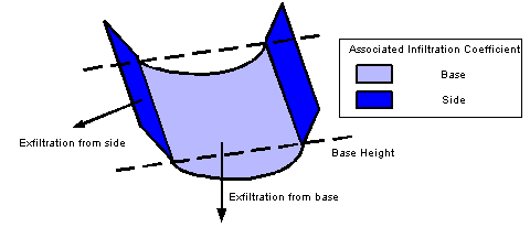
- Infiltration Coefficients- The rate of infiltration from the pond into the ground
- Levels and corresponding Plan Area and Perimetervalues defining the shape of the pond
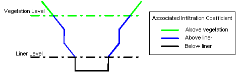
InfoWorks ICM calculates the wetted surface area above and below the liner / vegetation levels using Equation 2 (below) to calculate the areas of the sides of the pond, and multiplies this by the relevant infiltration coefficient to work out the infiltration losses (see Equation 1 above).
|
|
where: Al = plan area at lower point Au = plan area at upper point dH = difference in level Pl = perimeter at lower point Pu = perimeter at upper point |
As per the definition of the wetted surface area, the Base Area (Ab) is only applied to the first level of the pond.
A single subcatchment is associated with the pond node. The subcatchment area will usually correspond to the area at the highest level of the pond level-area table. InfoWorks determines direct rainfall into the pond from the current water surface area and the current rainfall rate. Rainfall that falls on the dry surface of the subcatchment is subject to he usual runoff processes (initial losses, runoff volume, runoff routing). Direct rainfall is assumed to have no losses and 100% runoff.
Evaporation is calculated by multiplying the current water surface area by the current evaporation rate.
Swales
Conduits can be used to model conveyance swales. The following SUDS parameters are required to model conveyance swales:
- Base height - Height above invert of conduit. This defines the nominal base area to which the Infiltration Coefficient (base) will be applied.
- Infiltration Coefficient (base) - Rate of infiltration from the conduit base to the ground.
- Infiltration Coefficient (side) - Rate of infiltration from the conduit sides to the ground.
The use of the SUDS parameters allow flow to leave the conduit via exfiltration at a uniform rate along the length of the swale.
InfoWorks ICM calculates a loss rate based on the wetted perimeter. The loss is applied to the node immediately downstream of the swale.
Lateral Inflows
There is the option to apply contributions from a subcatchment to a link. This is useful in representing a road or a car park with a swale running the length of it for example. As water runs off the area, the flows in the link will uniformly increase.
To model lateral inflow, specify a Link suffix in addition to a Node ID in the Subcatchment Data Fields.
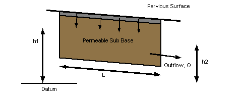
Permeable Pavements - Permeable Media Conduit
A conduit can be used to represent a permeable pavement. Setting the Solution Model of the conduit to Permeable, allows Permeable Media parameters to be set:
- Fill material conductivity- A measure of the material's ability to conduct water. Water flow increases as conductivity increases.
- Porosity - Ratio of voids volume to total volume of permeable media. Porosity directly affects the upstream and downstream depth values of the conduit. Depth varies in inverse proportion to porosity, e.g. if porosity is 30%, then the depth will be twice that of a conduit with porosity 60%.
Inflows to the permeable conduit are lateral inflows from subcatchments draining to the conduit, plus any inflow.
Outflows are determined by the conduit SUDS fields.
Discharge, Q, is calculated using Darcy's Law: rate of flow of water through a permeable formation is proportional to the change in elevation between points (Dh), the distance between the points (L) and the hydraulic conductivity (K) of the material the water flows through.
Discharge, Q is calculated as:
|
|
where: K = hydraulic conductivity A = cross sectional area of permeable formation Dh = difference in head (h1 - h2) |
Porosity
Some SUDS structures (soakaways or infiltration trenches for example) are filled with stones or gravel or sand, thus reducing the volume available for water. The Porosity represents this infill. A Porosity of 30% represents 30% air volume in the structure (70% of the volume is taken up by fill material).
This infill will affect the water level in the structure. It is equivalent to reducing the plan area of a node. So, a node of plan area 80m2 filled with stones of porosity 0.5 is equivalent to an unfilled node of plan area 40m2. InfoWorks makes this adjustment internally during a simulation to take account of the Porosity value.
Perimeter
Perimeters for various infiltration structures are calculated as follows:
- Loss through base only: P = 0
- Rectangular detention basin of width W and length L: P = 2 * (W + L)
- Circular soakaway of diameter D: P = π * D
- Trapezoidal swale with side slope s and length L: P = 2* L * sqrt(1 + s^2). This assumes infiltration from the sloping sides, but not at the ends.
SWMM WQ LIDs component
The SWMM WQ LIDs component is also included in the modelling of SUDS/LIDs structures in an InfoWorks network. In order to include this component, the simulation engine handles the following elements as described below:
- Internal routing - support washoff is routed via pervious or impervious surfaces as well directly to the outlet.
- Runon from subcatchments - washoff from a subcatchment that drains to another subcatchment is mixed with the washoff from the destination subcatchment.
- Effect of LIDs - the addition to subcatchment pollutant loads from wet deposition and upstream runon to LID areas are now determined.
- Drain outflow from LIDs - handles the drain outflows to the same subcatchment or to a different subcatchment or node.
- State files - SWMM hot start files include quality and ponded quality at subcatchments, so these are now present in simulation states (.sps files).
Note:
- As SWMM associates DWF and RDII with nodes and not subcatchments, InfoWorks ICM does the same. Therefore, runon from one subcatchment to another subcatchment will only include runoff (and washoff) from surfaces; wastewater is not included in runon flow.
- As SWMM5 only implements washoff and does not include any contribution from gully pots, a subcatchment draining to another subcatchment will be assumed to have no gully pots, i.e. there will only be contributions from SF1 and any pollutants attached to it.
- As the state of LID control is not saved in SWMM5, it is not saved in InfoWorks ICM.
- Water quality is handled by the simulation engine in the same way as SWMM. This is described in pages 123-125 in the Storm Water Management Model Reference Manual, Volume III – Water Quality (EPA/600/R-16/093), published by the U.S. Environmental Protection Agency (EPA). This manual is available to download at https://nepis.epa.gov.
However, for InfoWorks ICM version 8.5 and older, Cppt - the concentration of the pollutant in rainfall (mass/L) - is always zero in the simulation engine. Non-zero values are supported from version 9.0.
