Subcatchments
A subcatchment in the network represents the physical area from which a manhole or other inflow node collects water. Subcatchment objects used for InfoWorks and SWMM networks are described in the following sections.
 InfoWorks networks
A different set of subcatchments for each System Type in the network can be created. Subcatchments of different System Types are displayed as separate layers on the GeoPlan Window:
|
Storm |
Rainfall collection |
|
Foul |
Wastewater collection |
| Sanitary | Wastewater collection |
|
Combined |
Both rainfall and wastewater collection |
|
Overland |
Overland floodwater collection |
|
Other |
Other system type |
The total area covered by the network should be subdivided into a number of non-overlapping subcatchments, each of which will drain to one of the following:
- A single inflow node
- A single lateral link , which consists of a link suffix, which identifies the link, and an inflow node
- Multiple lateral links, each of which consists of a link suffix, which identifies the link, and an inflow node
- Another subcatchment
- A single 2D point source. This allows the hydrology aspects of a subcatchment to be applied directly to a 2D mesh.
The inflow node does not necessarily have to be physically located within the subcatchment. Although there may be pipes or channels joining nodes in the subcatchment to the inflow node(s), these may not be explicitly modelled. The capacity of these non-lateral links should be included in the total capacity of the inflow node in the model. There may also be other nodes within the subcatchment but these non-lateral nodes cannot have any inflow value.
The subcatchment drainage is displayed in the GeoPlan as large arrows.
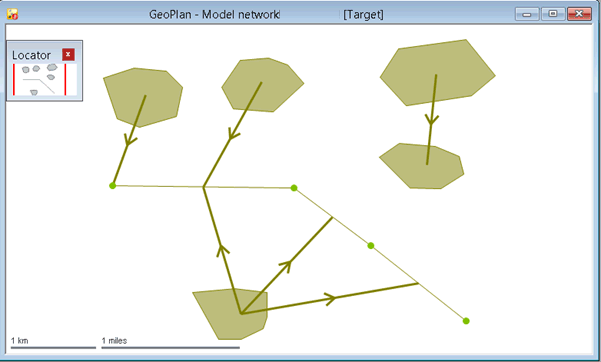
However, no arrows will be displayed when a subcatchment invalidly drains to more than one inflow node, link, subcatchment or 2D point source.
Rainfall data can be entered into the system and allocated between the subcatchments, giving InfoWorks ICM the data necessary for estimating inflows at each node in the network. This data may then be used to predict the effects on the network of various patterns of rainfall. See Using Rainfall Events for further information.
Most drainage systems have some constant or slowly varying baseflow that is present before the start of a storm. This could be from infiltration of groundwater or from foul drainage.
- A constant groundwater baseflow can be defined for the subcatchment.
- Wastewater drainage, generally from domestic use, can be defined using a Waste Water Profile. A Waste Water Profile can be defined in the subcatchment, but it is more usual to associate a specific profile with a particular Land Use. It would be unusual to override this default in the subcatchment.
- A Trade Flow Profile can also be defined in the subcatchment to describe flows from industrial premises. These are likely to be from unique sites and no default is provided by the Land Use.
Area Take Off functionality allows automatic calculation of runoff surface areas and the contributing areas of subcatchments using data imported from GIS.
Subcatchment population data can also be imported from a GIS file containing address point, seed point or census polygon data.
Relationship between Subcatchments, Land Uses, and Runoff Surfaces
A subcatchment describes an area draining to an inflow node (either directly or via one or more links or another subcatchment) or a 2D point source. Some of the parameters are defined directly in the subcatchment. The specific Runoff Surfaces are defined in a Land Use which is associated with one or more subcatchments. The Land Use also provides some default parameters for the subcatchment. These defaults can be over-ridden in the subcatchment data if necessary.
A Land Use contains a list of Runoff Surfaces particular to the type of Land Use being defined. Example Land Uses are Suburban or Industrial. It also contains default values for a number of factors, including the percentage of total area for each Runoff Surface, Population Density, and Connectivity. The three typical surface types used with the Wallingford Procedure are Road, Roof, and Pervious. The software allows use of up to 12 Runoff Surfaces per Land Use to support the modelling of more complex mixed surfaces.
A Runoff Surface describes the runoff characteristics of a specific surface type, for example Road or Roof.
SWMM networks
The total area covered by a SWMM network should be subdivided into a number of non-overlapping subcatchments, each of which will drain to one of the following:
- A single inflow node
- Another subcatchment
The inflow node does not necessarily have to be physically located within the subcatchment that receives its flow.
Subcatchment drainage in SWMM networks is displayed in the GeoPlan as large arrows. However, no arrows will be displayed when a subcatchment invalidly drains to more than one inflow node or subcatchment.
Rainfall data can be entered into the system and assigned to subcatchments via rain gages, giving InfoWorks ICM the data necessary for estimating inflows at each node in the network. This data may then be used to predict the effects on the network of various patterns of rainfall. See Using Rainfall Events for further information.
Subcatchments in a SWMM network are divided into pervious and impervious sub-areas. Surface runoff can infiltrate into the upper soil zone of the pervious sub-area, but not through the impervious sub-area. Impervious areas can are themselves divided into two sub-areas; one that contains depression storage and one that does not. Runoff from one sub-area in a subcatchment can be routed to the other sub-area, or both sub-areas can drain to the subcatchment outlet.
Runoff models
Each subcatchment can have one of the following runoff models assigned to it, which will be applied to its pervious area:
-
SWMM - A non-linear reservoir runoff routing model. A full description of this method can be found in the SWMM5 Reference Manual (Hydrology), which can be downloaded from the EPA website.
-
SCS curvilinear - The Natural Resources Conservation Service (formerly known as the Soil Conservation Service or SCS) runoff routing model that uses a curvilinear hydrographic shape for its dimensionless unit hydrograph. See the National Engineering Handbook Part 630 Hydrology (Chapter 16 - Hydrographs) for details.
-
SCS triangular - The SCS runoff routing model that uses a triangular hydrographic shape for its unit hydrograph.
You can choose which model to use by setting the Runoff model type property to the applicable model. As the SCS curvilinear and SCS triangular models require that a Curve number type of infiltration model is used, the Infiltration type property is automatically set to Curve_number when either of the SCS options are chosen. You can use the Curve number property to specify which curve number is to be used for the subcatchment. See Subcatchment Data Fields (SWMM) for details.
SCS runoff models
To generate a unit hydrograph for a subcatchment using either of the SCS runoff models, a time of concentration is required. This can either be specified by you, in the Time of concentration field, or calculated by the software when the system default flag (#D) is set in the Time of concentration field.
If #D is set, the time of concentration is calculated using the following time lag equation:
Tl = L0.8 (1000 / CN - 9)0.7 / (1900 S0.5)
Tc = Tl / 0.6
where:
Tl is the time lag in hours.
L is the hydraulic length in feet, specified in the Hydraulic length field.
CN is the curve number, specified in the Curve number field. A value of 0 cannot be used for CN, so if Curve number is set to 0 in the subcatchment properties, the software will use a value of 1 for CN in the lag equation.
S is the subcatchment slope in percent, specified in the Slope field. A value of 0 cannot be used for S, so if Slope is set to 0 in the subcatchment properties, the software will use a value of 0.001 for S in the lag equation.
Tc is the time of concentration in hours.
The time to peak (Tp) for the unit hydrograph is calculated using the following equation:
Tp = Tr / 2 + Tl
where Tr is duration of effective rainfall, and Tl is the time lag (i.e. a delay in time before the runoff reaches its peak over the subcatchment) in hours.
Note: The duration of effective rainfall is the same as the hydrograph timestep, which for SWMM networks, is fixed at 60 seconds for both SCS curvilinear and SCS triangular runoff models.
The peak flow rate for the unit hydrograph is calculated as:
Qp = Shape_factor A / Tp
where:
Qp is the peak flow rate
Shape_factor is the value specified in the Shape factor field
A is the area of the subcatchment draining to the location of the unit hydrograph
Tp is the time to peak, in hours, of the unit hydrograph.
Once Tp and Qp are known, actual time and flow rate ordinates for the SCS curvilinear tr-hour unit hydrograph are determined by multiplying the dimensionless time (T/Tp) and the dimensionless flow rate ordinates (Q/Qp) by Tp and Qp respectively.
See the National Engineering Handbook Part 630 Hydrology (Chapter 16 - Hydrographs) for further information about the SCS curvilinear and triangular unit hydrographs.
Groundwater flow
A subcatchment can be associated with an aquifer and a node in the drainage system that exchanges groundwater with the aquifer. By setting the coefficients that determine the rate of lateral groundwater flow between the aquifer and the node, ICM can calculate groundwater flow as a function of groundwater and surface water levels using the following EPA SWMM standard lateral groundwater flow equation:
|
|
where: QL is the lateral groundwater flow A1 is the groundwater coefficient Hgw is the height of saturated zone above bottom of aquifer Hcb is the height of surface water at receiving node above aquifer bottom B1 is the groundwater exponent A2 is the surface water flow coefficient B2 is the surface water flow exponent Hsw is the height of surface water at the aquifer node above aquifer bottom A3 is the surface groundwater coefficient |
The groundwater flow equation height inputs, in relation to the bottom of the aquifer, are illustrated in the following figure:
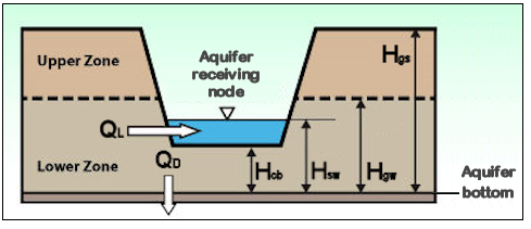
The rate of percolation to deep groundwater is calculated by ICM using the following EPA SWMM standard deep groundwater flow equation:
|
|
where: QD is the deep groundwater flow LGDR is the aquifier's lower ground loss rate Hgw is the height of saturated zone above bottom of aquifer Hgs is the height of surface water at receiving node above aquifer bottom |

These standard equations can be customised using the Groundwater Flow Equation Editor which is accessed from the subcatchment's properties.
Further information about the EPA SWMM standard lateral and deep groundwater flow equations can be found in the SWMM5 User Guide.
