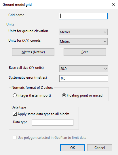
Ground Model Grid (Import/Export) Dialog
This dialog is used for importing and exporting gridded ground models.
During import, the dialog is displayed when you right-click
During export, the dialog is displayed when you right-click a ground model (grid) in the Explorer window, select Export | to ESCR ASCII grid files, select a folder in the Windows Save As dialog, then click Save.
| Item | Import | Export | ||||||||
|---|---|---|---|---|---|---|---|---|---|---|
| Grid name | The name of the gridded ground model. | Read-only. Name of the ground model grid that is being exported. | ||||||||
| Units |
|
These controls can be used to set the units for the export file, but they do not affect any other fields on the dialog. | ||||||||
| Base cell size (XY units) |
This is calculated based on the highest resolution available in the imported data. Resolution can be increased by selecting a smaller cell size from the dropdown list if available. |
Not used for export. | ||||||||
| Systematic error (metres) |
The elevation offset. Correction of Z values will be applied on import. For example, if a systematic error of -2 is entered, Z values will be increased by 2 on import. |
Not used for export. | ||||||||
| Numeric format of Z values |
|
Not used for export. | ||||||||
| Data type |
This can be used to add information about the source of the ground model data to the ground model, e.g. LIDAR. A ground model theme on data type can subsequently be applied to the GeoPlan view.
|
Not used for export. | ||||||||
| Use polygon selected in GeoPlan to limit data |
Available if there is a single polygon selected in the current GeoPlan window. If checked, limits the import of files to those files containing data that overlaps the selected polygon. |
Not used for export. |

