Displaying a Ground Model on the GeoPlan
Ground models can be viewed on the GeoPlan Window using a contour plot. Contour lines join points with the same elevation. There is no interpolation between the contour lines, but if the elevation range is split into enough individual ranges, a fairly good grading effect can be achieved.
You can save the current themes and view the properties of current themes on the Layer Theme Editor
To display the ground model:
-
- Right-click on the GeoPlan Window and choose Properties & Themes from the popup menu. This displays the Layers and Themes page of the GeoPlan Properties dialog.
- Click the Edit button of the Theme column for the Ground Model object layer. The Layer Theme Editor is displayed:
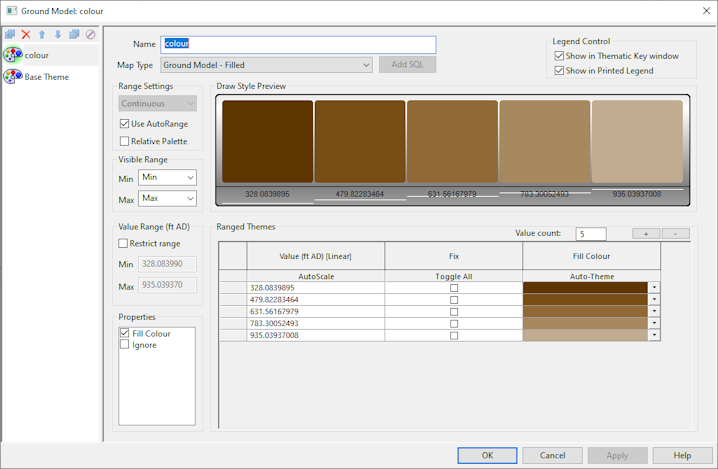
- The default ground model theme is colour and is based on ground levels (z). The default Map Type is Filled but other types are also available (see table below). Fill contours of ground level values have been auto-themed so the Draw Style Preview shows a graduated set of colours going from dark brown for low ground levels to light brown for high ground levels.
- Change the name of the Colour theme in the Name box if required and select a different map type in the Map Type dropdown.
- Set up your contour parameters as required and click OK to commit your changes. See the Ground model theme data fields table below.

You cannot create additional Ground Model
 Tip
Tip The provided Ground Model theme will only be editable if a ground model has been loaded onto the GeoPlan.
| Section | Options | ||||||||||
|---|---|---|---|---|---|---|---|---|---|---|---|
|
Map Type |
The options available in this section depend on the type of Ground Model (Grid or TIN) being used.
|
||||||||||
|
Range Settings |
The only available option is Continuous. This will display the Ground Model based on a series of ranges of elevation.
|
||||||||||
|
Visibility Range |
The Min and Max boxes determine the map scale/zoom level at which the ground model is visible. |
||||||||||
|
Value Range |
When Restrict Range is checked, you can restrict the range of values displayed in Ranged Themes grid to the values specified in the Min and Max boxes. The maximum value must be greater than the minimum value. |
||||||||||
|
Ranged Themes grid |
See the Layer Theme Editor topic for details on how to set up themes using the controls in this grid. Note that Value count for a ground model theme is editable. This lets you type in the number of values allowed for the range, and provides an alternative to using the Plus and Minus buttons ( Two important points:
|
 ) - to add or remove values within the range. When you increase or decrease the number of values allowed, the values displayed in the