Update from Ground Model Dialog
This dialog is used to update network object data by sampling a selected Ground Model.
- River line section data
- Storage/pond node level-area data
- Base linear structure crest level data (only structures with Crest level set to Irregular can be updated)
- Bridge linear structure invert level data (only structures with Invert level set to Irregular can be updated)
The dialog is displayed when a network object that can be updated is included in the current selection and the Model | Update from ground model menu option is selected.
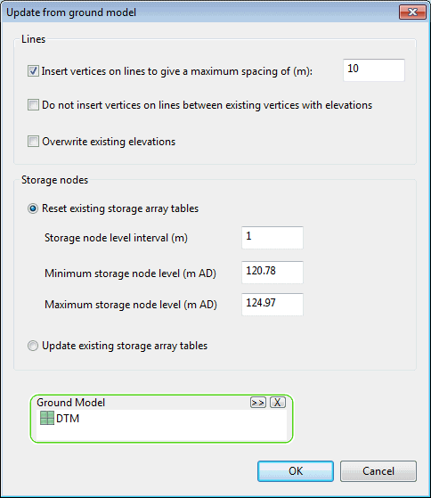
| Option | Description |
|---|---|
| Insert vertices on lines to give a maximum spacing of |
Applicable to lines (river lines, base linear structures and bridge linear structures). If existing vertices of the lines are separated by a distance greater than the specified maximum spacing, extra vertices will be inserted at regular intervals between existing vertices to meet the maximum spacing specified. |
| Do not insert vertices on lines between existing vertices with elevations |
Applicable to lines (river lines, base linear structures and bridge linear structures). Enabled when Insert vertices to give a maximum spacing of option is selected. When this option is checked, new vertices will not be inserted between vertices that already have elevation values. Intended for use when extending a line. Insertion of vertices and ground model sampling can be carried out for the extended parts of the line leaving the original part of the line unchanged. |
| Overwrite existing elevations |
Applicable to lines (river lines, base linear structures and bridge linear structures). Check this option to overwrite the original elevation values at existing vertices with values determined from the Ground Model. If this option is unchecked, elevation values at existing vertices will be retained. Existing vertices with no elevation specified will be updated with elevations sampled from the Ground Model. |
| Reset existing storage array tables |
Applicable to storage/pond nodes. Select this option to recalculate level-area values in the storage array table. Existing level-area values will be removed prior to update. Set parameters for setting level-area values:
|
| Update existing storage array tables |
Applicable to storage/pond nodes. Select this option to recalculate the area value for existing levels in the storage array table. |
| Ground Model |
Select the ground model to be sampled. If a ground model is currently loaded onto the GeoPlan, this selection box will be automatically populated. |
