Processing Spatial Data
Spatial Data can be any geographical based information that you want to include in your InfoWorks model, and that can be sensibly attached to pipes in the network.
You could include other geographical based data that is not attached to specific pipes by including an additional GIS layer on the GeoPlan Window.
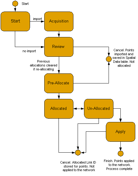
Spatial Data is processed using the Spatial Data Analysis Wizard. The process, described below in more detail, is:
- choose to import data, allocate previously un-allocated data to pipes, re-allocate existing data to pipes
- if importing, map data fields in the external source to fields in the Spatial Data Grid. See Spatial Data Fields for details of the fields.
- review the data prior to allocation. Choose to limit points used for allocation to a specific geographical area
- choose to limit the pipes used in the allocation process, either by geographical area or using a selection list
- set parameters by which the points chosen in step 3 are linked to pipes chosen in step 4. You can review the results and repeat allocation as often as necessary
- review any unallocated points. You can return to step 5, and repeat steps 5 and 6 as often as you want
- choose to store allocated and/or unallocated points.
Using the Wizard
To start the Spatial Data Analysis Wizard:
- Choose Spatial Data Analysis from the Model menu. The Model menu is only visible when there is a network open, and one of the network views is the Current Active WindowThe current Active Window in any Microsoft Windows application has a differently coloured title bar to all the other windows. In the default colour scheme, the active window title bar is blue, all other windows have a grey title bar.. This displays the Start Page of the wizard.
- When you open the wizard, InfoWorks searches for existing spatial data points in the database. If the spatial data table is large, you will see a progress bar entitled Scanning Spatial Data Table.
The schematic below shows the steps through the Spatial Data Analysis Wizard. You can click one of the boxes to take you to the relevant section for that page.
Spatial Data Allocation Wizard

 . This indicates that
there is additional information available.
. This indicates that
there is additional information available. button.