About spatial data
You can import spatial data information into an InfoWorks network and then allocate the data to appropriate pipes in the network using a series of rules.
The spatial data points can represent any form of spatial data you want to associate with your network.
You can define spatial data points yourself using the Spatial Data grid window or the Spatial Data Property Sheet. Or you can import the data from:
- CSV file
- GIS data file - this must be of a type compatible with your current GIS component in the GeoPlan window.
- GIS layer - already loaded in the GeoPlan
See Processing Spatial Data for more about the import and allocation process.

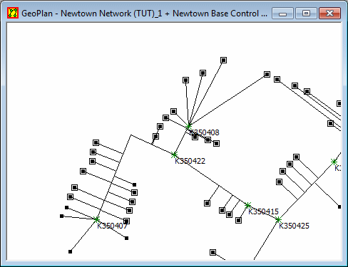
Spatial Data points displayed on the GeoPlan
Spatial data parameters
As a minimum, you need to define X and Y coordinates and a unique Key. If you are importing the data you can leave the Key blank, and InfoWorks will generate a Key based on the X and Y values.
Other parameters which you can define are:
- Type - you can set a category for the spatial data point. InfoWorks includes three built in categories - Burst, Complaint, and Water Quality Failure.
- Details - a short description for the point
- Date and Time - if appropriate
- Reference - an optional additional reference, perhaps referring to additional data stored in another database or filing system
You can also keep more information about the spatial data point on the Notes page of the property sheet. These Notes cannot be imported.
See Spatial Data Fields for more information.
Allocating spatial data to the network
You allocate spatial data to the network using the Spatial Data Analysis Wizard. The allocation process is iterative, so you can use trial and error to improve allocation until the results are acceptable.
Viewing spatial data points
You can display spatial data points on the GeoPlan window. SeeViewing spatial data on the GeoPlan.
You can also view and edit spatial data on the Spatial Data grid window and the Spatial Data property sheet.
