Subcatchment Results Data Fields (InfoWorks)
All results fields are displayed on the results grid and on the Subcatchment Property Sheet while viewing a replay of a simulation.
Time varying results are shown with the field name in an alternate colour on the grid. Non time varying results have the field name in the normal black type.
 Results data fields will be displayed only
if a Ground Infiltration Event is used in simulation
Results data fields will be displayed only
if a Ground Infiltration Event is used in simulation
 Results data fields will only be displayed for a Water Quality simulation
Database Table Name: __IWR_Subcatchment
|
Field Name |
Help Text |
Database Field |
|||
|---|---|---|---|---|---|
|
Foul flow |
Total waste water flow for the subcatchment. |
Q |
QFOUL |
||
|
Trade flow |
Trade flow for the subcatchment. |
Q |
QTRADE |
||
|
Rainfall |
Rainfall intensity. |
R |
RAINFALL |
||
| Exceedance flow |
Applicable to a subcatchment that has its Limit drain to capacity box checked. The flow, in excess of the Capacity limit, from the subcatchment that is either lost or directed to the 2D element where its Drains to node is located. |
Q | Q_EXCEEDANCE | ||
|
Rainfall profile |
The rainfall profile applied to the subcatchment during the simulation. During most simulations this will be the profile entered in the Rainfall profile field. When using a Rainfall Event containing rain-gauge boundary data, this profile depends on which rain-gauge boundary contains the drainage node. |
|
RAINPROF |
||
|
Effective Rainfall |
This is the total depth of rainfall on impervious surfaces, minus evaporation and initial losses. |
Y |
EFFRAIN |
||
| Evaporation profile | The evaporation profile applied to the subcatchment during the simulation. This is the profile that is specified on the Evaporation profile field in the subcatchment's properties. | EVAPPROF | |||
| Evaporation rate | The evaporation rate for the subcatchment. | EV | EVAPRATE | ||
|
Impervious flow to SUDS |
The flow from the impervious area of the subcatchment to the SUDS structures. |
Q |
Q_LID_IN |
||
|
SUDS surface outflow |
The surface outflow from the SUDS structures. |
Q |
Q_LID_OUT |
||
|
Base flow |
The base infiltration flow into the system from the subcatchment. This is a constant inflow into the system. |
Q |
QBASE |
||
| Exceedance volume |
Applicable to a subcatchment that has its Limit drain to capacity box checked. The total volume, in excess of the Capacity limit, from the subcatchment that is either lost or directed to the 2D element where its Drains to node is located. |
VO | V_EXCEEDANCE | ||
|
SUDS drain outflow |
The drain outflow from LIDs/SUDS structures. |
Q |
Q_LID_DRAIN |
||
|
Total outflow |
The total outflow (base flow, foul flow, trade flow, runoff, infiltration, RDII, ARMA, SUDS inflow and outflow) from the subcatchment |
Q |
QCATCH |
||
|
Runoff |
Flow into the drainage node for the subcatchment from surface runoff. |
Q |
RUNOFF |
||
|
Runoff (raw) |
Flow into the drainage node for the subcatchment from surface runoff excluding ARMA. |
Q |
QRAW |
||
|
Runoff from surface |
Flow into the drainage node for the subcatchment from individual surface types. |
Q |
QSURF<SS> |
||
| Precipitation index on surface |
Applicable when using the UKWIR Runoff Model. Precipitation Index, PI, for paved surfaces. NAPI for pervious surfaces. |
Y | PREC_IDX<SURF> | ||
|
Net API30 |
Net API30 (when using New UK runoff surface) |
Y |
NAPI |
||
| Computed baseflow |
Applicable when using the ReFH Runoff Model. The calculated baseflow. |
Q | CMPBASEFLOW | ||
| Rainfall-driven baseflow |
Applicable to PDM subcatchments. Baseflow component of total PDM runoff. |
Q | PDM_BASEFLOW | ||
| Interflow |
Applicable to PDM subcatchments. Interflow component of total PDM runoff. |
Q | PDM_INTERFLOW | ||
| Surface flow |
Applicable to PDM subcatchments. Surface flow component of total PDM runoff. |
Q | PDM_SURFACEFLOW | ||
| Soil moisture deficit |
Applicable to PDM subcatchments. Soil moisture deficit |
PDM_SMD | |||
| Inflow to surface store |
Applicable to PDM subcatchments. Inflow into surface water store |
I | PDM_TOSURFACE | ||
| Inflow to interflow store |
Applicable to PDM subcatchments. Inflow into interflow store. |
I | PDM_TOINTERFLOW | ||
| Inflow to groundwater store |
Applicable to PDM subcatchments. Inflow into groundwater store. |
I | PDM_TOBASEFLOW | ||
| Actual evaporation |
Applicable to PDM subcatchments. Actual evaporation. |
EV | PDM_EVAPORATION | ||
| Infiltration excess |
Applicable to PDM subcatchments. Infiltration excess runoff |
I | PDM_EXCESS | ||
|
Ground store level |
Level above datum of water in the Ground Store (see diagram below). |
Z |
GRNDSTOR |
|
|
|
Lost to groundwater |
The flow out of the groundwater storage reservoir that provides no contribution (see diagram below). |
Q |
LOSTTOGW |
|
|
|
Infiltration to soil |
Rainfall that infiltrates into the soil. |
Q |
QINFSOIL |
||
|
Soil store depth |
Depth of water in the Soil Store (see diagram below). |
Y |
SOILSTOR |
|
|
|
Soil store inflow |
Flow into the drainage node for the subcatchment from Soil Storage (see diagram below). |
Q |
QSOIL |
|
|
|
Ground store inflow |
Flow into the drainage node for the subcatchment from Ground Water Storage (see diagram below). |
Q |
QGROUND |
|
|
|
Infiltration to groundwater |
Percolation flow from the soil into the groundwater. |
Q |
QINFGRND |
|
|
|
Groundwater Inflow |
Flow into the drainage node for the subcatchment from groundwater:
(see diagram below) |
Q |
QINFILT |
|
|
|
Pervious melt |
Applicable to subcatchments with associated snow pack. Snow melt rate from pervious surfaces. |
R |
PERVMELT |
||
|
Impervious free water |
Applicable to subcatchments with associated snow pack. Free water depth on impervious (non-ploughable) areas. |
RD |
IMPFW |
||
|
Impervious melt |
Applicable to subcatchments with associated snow pack. Snow melt rate from impervious surfaces. Calculated as the area weighted average of the melt rates from ploughable and non-ploughable impervious areas. |
R |
IMPMELT |
||
|
Impervious snow depth |
Applicable to subcatchments with associated snow pack. Depth of snow on impervious (non-ploughable) areas. |
RD |
IMPSNOW |
||
|
Pervious free water |
Applicable to subcatchments with associated snow pack. Free water depth on pervious areas. |
RD |
PERVFW |
||
|
Pervious snow depth |
Applicable to subcatchments with associated snow pack. Depth of snow on pervious areas. |
RD |
PERVSNOW |
||
|
Ploughable free water |
Applicable to subcatchments with associated snow pack. Free water depth on ploughable areas. |
RD |
PLOWFW |
||
|
Ploughable snow depth |
Applicable to subcatchments with associated snow pack. Depth of snow on ploughable areas. |
RD |
PLOWSNOW |
||
|
RDII Flow |
The Rainfall Derived Infiltration and Inflow into the system from the subcatchment. |
Q |
QRDII |
||
|
Mass of <SFX> remaining for washoff at end of simulation |
Mass of sediment fraction remaining for washoff at end of simulation, where <SFX> represents SF1 or SF2 and <PPP> the represents pollutant name. The Innovyze washoff model supports SF1 only. |
M |
MWRSF1 |
|
|
|
Washoff <CFX> dissolved |
Mass inflow of dissolved pollutant from washoff, where <CFX> represents the coliform pollutant name. |
MFSI |
MW<CFX>DIS |
|
|
|
Washoff <PPP> dissolved |
Mass inflow of dissolved pollutant from washoff, where <PPP> represents the pollutant name. |
MFSI |
MW<PPP>DIS |
|
|
|
Washoff <CFX> <SFX> |
Mass inflow of pollutant attached to the sediment fraction from washoff, where <SFX> represents SF1 or SF2 and <CFX> represents the coliform pollutant name. The Innovyze washoff model supports SF1 only. |
MFSI |
MW<CFX>SFX |
|
|
|
Washoff <PPP> <SFX> |
Mass inflow of pollutant attached to the sediment fraction from washoff, where <SFX> represents SF1 or SF2 and <PPP> represents the pollutant name. The Innovyze washoff model supports SF1 only. |
MFSI |
MW<PPP>SFX |
|
|
|
Washoff <CFX> total |
Total pollutant washoff, where <CFX> represents the coliform pollutant name. |
MFSI |
MW<CFX>TOT |
|
|
|
Washoff <PPP> total |
Total pollutant washoff, where <PPP> represents the pollutant name. |
MFSI |
MW<PPP>TOT |
|
|
| Washoff <PPP> detrital |
Washoff detrital, where <PPP> represents pollutant name. Only available for SWMM washoff model runs. |
MW<PPP>DET |
|
||
|
Mass of <CFX> available for washoff at end of initialisation |
Mass of pollutant available for washoff at end of initialisation phase, where <CFX> represents the coliform pollutant name. |
M |
MW0<CFX> |
|
|
|
Mass of <PPP> available for washoff at end of initialisation |
Mass of pollutant available for washoff at end of initialisation phase, where <PPP> represents the pollutant name. |
M |
MW0<PPP> |
|
|
| Mass of coliforms available for washoff at end of intiialisation | Mass of coliforms available for washoff at end of initialisation phase | MW0COL |
|
||
|
Mass of <SFX> available for washoff at end of initialisation |
Mass of sediment fraction available for washoff at end of initialisation phase, where <SFX> represents SF1 or SF2. The Innovyze washoff model supports SF1 only. |
M |
MW0SFX |
|
|
| Mass of <PPP> detrital available for washoff at end of initialisation |
Mass of detrital available for washoff at end of initialisation, where <PPP> represents the pollutant name. Only available for SWMM washoff model runs. |
M | MW0<PPP>DET |
|
|
|
Mass of <CFX> available for washoff for entire simulation |
Mass of pollutant available for washoff during simulation period, where <CFX> represents the coliform pollutant name. |
M |
MW1<CFX> |
|
|
|
Mass of <PPP> available for washoff for entire simulation |
Mass of pollutant available for washoff during simulation period, where <PPP> represents the pollutant name. |
M |
MW1<PPP> |
|
|
| Mass of coliforms available for washoff for entire simulation | Mass of coliforms available for washoff during simulation period | MW1COL |
|
||
|
Mass of <SFX> available for washoff for entire simulation |
Mass of sediment fraction available for washoff during simulation, where <SFX> represents SF1 or SF2. The Innovyze washoff model supports SF1 only. |
M |
MW1SFX |
|
|
| Mass of <PPP> detrital available for washoff for the entire simulation |
Mass of detrital available for washoff for the entire simulation, where <PPP> represents the pollutant name. Only available for SWMM washoff model runs. |
M | MW1<PPP>DET |
|
|
| Washoff colifiorms | Mass inflow of coliforms from washoff | MWCOLDIS |
|
||
|
Mass of <CFX> remaining for washoff at end of simulation |
Mass of pollutant remaining for washoff at end of simulation, where <CFX> represents the coliform pollutant name. |
M |
MWR<CFX> |
|
|
|
Mass of <PPP> remaining for washoff at end of simulation |
Mass of pollutant remaining for washoff at end of simulation, where <PPP> represents the pollutant name. |
M |
MWR<PPP> |
|
|
| Mass of <PPP> detrial remaining for washoff at end of simulation. |
Mass of detrital remaining for washoff at the end of the simulation, where <PPP> represents the pollutant name. Only available for SWMM washoff model runs. |
M | MWR<PPP>DET |
|
|
| Mass of coliforms remaining for washoff at end of simulation | Mass of colifomrs remaining for washoff at end of simulation | MWRCOL |
|
||
|
Washoff <SFX> |
Mass inflow of sediment fraction from washoff, where <SFX> represents SF1 or SF2. The Innovyze washoff model supports SF1 only. |
MFSI |
MWSFX |
||
| Soil moisture content | Value for soil moisture content used in simulations that use the ReFH model | REFH_C |
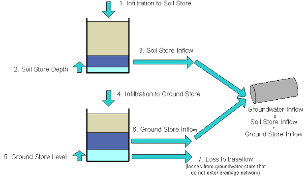
Ground Water Infiltration Model
