Generating Overland Flow Paths - From Ground Model
This functionality assumes a hydrologically correct Gridded Ground Model.
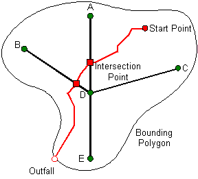
Links and nodes of system type "Overland" representing the Overland Flow Path can be automatically generated based on a starting selection of existing nodes and a Gridded Ground Model.
The flow path starts at a selected node and follows the path of steepest descent (as defined by the ground model). The flow path continues until one of the following conditions occurs:
- The flow path comes within a user defined snapping distance of a link / node: snapping will only take place to unsealed nodes and conduit / channel links of permitted system types (as specified on the Generate Overland Flow Paths Dialog)
- The flow path reaches the extents of the ground model
- The flow path reaches the extents of a bounding polygon (if bounding polygon specified)
- The flow path enters a pit / flat region from which no outward flow direction is defined
Tracing will not be carried out from a Sealed Manhole, Outfall or node that is already connected to a downstream Overland link.
For flow paths that do not snap to the network, there is the option to create an overland link connected to an outfall node at the point at which the flow path terminates.
To generate Overland Flow Paths a Gridded Ground Model must be open on an editable GeoPlan:
- Select the nodes on the GeoPlan from which Overland Flow Paths are to be traced.
- Select Generate 1D overland flow paths | From ground model grid from the Model menu. This displays the Generate Overland Flow Paths Dialog.
- Set parameters on the Generate Overland Flow Paths Dialog:
- Bounding Polygon (optional): Only selected nodes within the polygon will be traced from. The trace will be terminated if it reaches the extents of the bounding polygon.
- Snapping Distance: The distance to a link / node that overland flow path must be within, before snapping will occur.
- Grid Resolution: Selecting a resolution of larger cell size may aid inference of flow direction to avoid termination of flow paths in local pits.
- Snapping Behaviour: Select whether to insert a new node or connect to a downstream node when snapping to a non-overland link. (A new node will always be inserted when snapping to an overland link).
- Flow paths that fail to rejoin network: An overland link and outfall node will be created for paths that fail to rejoin the network only if the Create a link and outfall option is checked.
- System Types: Snapping of the overland flow path to the existing network will be allowed only to selected system types.
- Digitisation Defaults: Change digitisation defaults for use when creating new overland links and nodes.
- Click OK
Overland links and nodes will be generated according to the settings on the Generate Overland Flow Paths Dialog. Nodes and links created are added to the current selection as the operation progresses.
Note that new nodes created by snapping to overland links are not derived from digitisation defaults. These nodes will be created as overland storage nodes with dimensions derived from the links that they join.
An HTML log will be displayed containing details of the flow path definitions.
