Surface Pollutant Editor
![]()
 Water Quality
The Surface Pollutant Editor is used to define the parameters used by the Surface Pollutant Model to calculate the buildup and washoff of pollutants on catchment surfaces and in gully pots. The editor is used to:
- Define Pollution Indices. These are used to calculate concentrations of dissolved pollutants and mass of attached pollutants
- Define global buildup and erosion characteristics for sediment
- Define the parameters for the Sediment Fractions. These parameters are used by the Surface Pollutant model and when calculating sediment transport in the drainage network.
Surface pollutant parameters define additional characteristics for subcatchments and are therefore treated as part of the network.
To display the Surface Pollutant Editor for the current network, click on the Surface Pollutant Editor icon ( ) from the Modelling Grid Windows toolbar.
Editor Layout
The editor displays a series of records (rows on the grid).
The surface pollutant parameters can contain the following record types, which must be entered in the order listed, with one or more of each type of record:
- Title record
- Buildup Parameters Record
- Erosion Parameters Record
- Pollutants Record
- Potency Factor Equation Record
- Potency Factor Equation Group Record
- Gully Pot Equation Record
- Gully Pot Equation Group Record
- Surface Definition Record
- Sediment Record
The Sediment Fraction parameters are always defined in the bottom rows of the editor. You can add a maximum of two Sediment Records below the last Surface Definition Record.
The buildup and erosion parameters are defined in the first two rows below the title.
The rest of the editor is dedicated to defining Pollution Indices. The final definition of a Pollution Index is given in a Surface Definition Record. This brings together other data and equations defined in previous records.
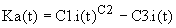
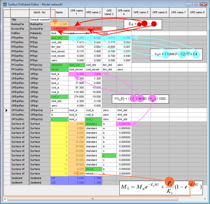
The image below shows an example. Click on a row in the image to go to information about each record type and the fields they contain. Use the Back button to return to the image.

 . This indicates that
there is additional information available.
. This indicates that
there is additional information available. button.
Image Key
Related parts of the image are highlighted in the same colour. The arrows show the relationship between values defined in the editor and parameters in the equations used in the model.
|
Cell Colour |
Explanation |
|---|---|
|
|
This colour indicates the ID fields for the Pollution Indices. There are 12 defined in this network. You can have a maximum of 99, with numeric IDs between 1 and 99. |
|
|
This colour shows the parameters for the Surface Buildup Equation. The block of values in the lower half of the view are the Surface Buildup Factor parameters defined for each Pollution Index in the Surface Definition Record. |
|
|
This colour shows the Surface Erosion Equation parameters. These are all defined in the Erosion Parameters Record. |
|
|
This colour shows the Potency Factor Equation parameters. You define a set of parameters for each equation. You need at least one equation for each pollutant being modelled. |
|
|
The green cells show the links between the different records in the editor. Look for matching names to see how equations are added to groups and groups included in Pollution Indices. |
|
|
This colour shows the parameters for the Gully Pot Equation. You do not define gully pot value (Vg) directly. Enter a value for the gully pot depth for each Pollution Index. This is then multiplied by the area of Runoff Surface 1 from the Land Use to give gully pot volume. By convention, Runoff Surface 1 is the road surface. |
|
|
These are the parameters defining the sediment fraction characteristics. |
Description of Data Records
|
Record Title |
Description and Record Fields |
||||||||||||||
|---|---|---|---|---|---|---|---|---|---|---|---|---|---|---|---|
|
The contains a short description of the data You should have just one. |
|||||||||||||||
|
The Buildup Parameters Record describes some of the data needed to calculate the mass of sediment buildup on the catchment surface. You should have just one Buildup Parameters Record. See Surface Pollutant Build-Up for more information
|
|||||||||||||||
|
The Erosion Parameters Record defines data used in the calculation of the sediment deposits left on the catchment surface and washed off into the drainage system during a simulation. You should have just one Erosion Parameters Record.
|
|||||||||||||||
|
The Pollutants Record defines the pollutant types available to be washed off subcatchment surfaces. You should have just one Pollutants Record. See Water Quality Determinants for more information.
|
|||||||||||||||
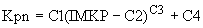
|
The Potency Factor Equation Record defines an equation used to determine the potency factors of pollutants. Potency factors (Kpn) are used to relate surface mass of sediment to surface mass of pollutant and are calculated using the potency factor equation:
You must define at least one Potency Factor Equation Record. You can define a maximum of thirty records. See Surface Washoff and Gully Pot Flushing for more information.
|
|||||||||||||||
|
The Potency Factor Equation Group Record defines a collection of potency factor equations, one for each pollutant available to be washed off a subcatchment surface. You define the potency factor equations themselves in the Potency Factor Equation Record. You must define at least one Potency Factor Equation Group Record. You can define a maximum of ten records.
|
|||||||||||||||
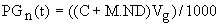
|
The Gully Pot Buildup Equation Record defines the coefficients for a gully pot buildup equation of the form:
The software uses this equation to determine the buildup of dissolved pollutants in the gully pots during the buildup period of the simulation, and the buildup for each simulation timestep. You must define at least one Gully Pot Buildup Equation Record. You can define a maximum of thirty records.
|
|||||||||||||||
|
The Gully Pot Buildup Equation Group Record defines a collection of Gully Pot Buildup Equations, one for each pollutant available to be washed off a subcatchment surface. The default surface pollutant parameters (default.wpf) contain three gully pot buildup equation groups. These refer to the following land uses:
You must define at least one Gully Pot Buildup Equation Group Record. You can define a maximum of ten records.
|
|||||||||||||||
|
The Surface Definition Record defines the sediment buildup on subcatchment surfaces and in gully pots, and the potency of pollutants attached to these sediments, for different surface types. The surface type is identified by its Pollution Index. The Pollution Index is the water quality equivalent of a Runoff Surface. The Pollution Index is associated with a subcatchment through the Land Use definition, in a similar way to Runoff Surfaces. Only one Pollution Index is associated with each Land Use. The Land Use can have up to twelve Runoff Surfaces. The default surface pollutant parameters (default.wpf) contain twelve Surface Definition Records. There is one record for each of the twelve default Land Uses. There must be at least one Surface Definition Record. The maximum number of definitions is 99.
|
|||||||||||||||
|
Sediment records define the physical characteristics of the different sediment fractions. It is not essential to specify any sediment records. The software uses default values for the sediment characteristics in this case. These defaults are:
The maximum number of records is two. See Water Quality Determinants and Sediment for more on sediment characteristics.
|