Land use definitions
Land Use definitions are used to define demand parameters for different types of area based demand.
There are three methods by which Land Use can be defined:
- Property Density - Defined by number of properties per unit area and specific consumption per property.
- Demand Density - Defined by demand per unit area.
- Land Use Demand - Defined by total average demand for the area.
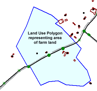
The geographical area to which a Land Use applies is defined by a polygon, which can either be digitised on the GeoPlan Window, or imported from a GIS file.
Land Use definitions are created in the Land Use Grid View of the Polygons Grid, and can be edited in the grid or on the Land Use Property Sheet.
A Land Use definition can be made up of one or more Land Use Demand objects.
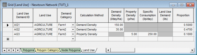
In the example above:
- The Land Use 'AGRICULTURE' is made up of three Land Use Demand ID objects (AG1, AG2, AG3).
- The Demand Category field refers to a Demand Diagram category.
- The Proportion field is used to define what proportion of demand each Land Use Demand ID contributes to the Land Use and is applied as a scaling factor to the calculated demand.
- The Demand Density, Property Density, Specific Consumption and Land Use Demand fields can be used to calculate demand to be assigned to the network. Alternatively, demand values specified at Polygons can be used in preference to the Land Use definition values. See Calculation of Land Use Demand at Nodes for details.
Assigning land use polygon demand to the network
To assign the Land Use Polygon demand to nodes in the network, the area of the Land Use Polygon that contributes demand to each node must be calculated and the Land Use demand divided between the nodes accordingly. To determine the contributing area to each node, the Land Use Polygon is subdivided by defining Node Polygons.
Node Polygons can be digitised directly onto the GeoPlan Window, or can be created automatically using the Thiessen PolygonGiven a number of points within an area (nodes for example), Thiessen Polygons are used to completely divide up the area so that, for each point, there is a polygon whose boundaries define the area that is closer to that point than to any other point. method. See Creating Node Polygons Within Selected Polygons for further information.
Once Land Use definitions and contributing areas have been allocated to a node, demand to be applied to the node is calculated: either using demand values specified as part of the Land Use definition, or using demand values specified at the Land Use Polygon. The calculated demand can be viewed in the Node Demand Page of the node property sheet. The values used for calculating demand at the node can be viewed in the Land Use Page of the property sheet.
See Allocating Land Use Demand to Nodes and Calculation of Land Use Demand at Nodes for further details on Land Use demand allocation.
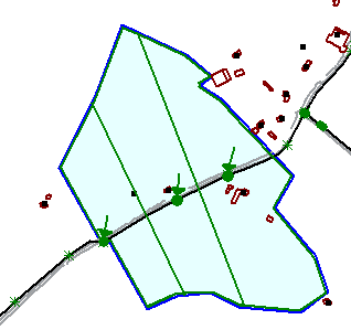
Node Polygons defined within Land Use Polygon
