Node polygons
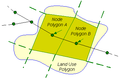
A Node Polygon is used to represent the geographical area in the network that contributes to demand at an associated node.
Node Polygons are used to calculate the proportion of demand from a Land Use area to be assigned to a node. To avoid duplication of demand, node polygons should not overlap. The associated node does not necessarily have to be physically located within the polygon. A single node may have any number of associated node polygons.
Node Polygons can be created by drawing polygons directly in the GeoPlan Window or by importing via the Open Data Import Centre. See Creating Polygons for more information.
Node Polygons can also be created within a selected bounding polygon using the Thiessen PolygonGiven a number of points within an area (nodes for example), Thiessen Polygons are used to completely divide up the area so that, for each point, there is a polygon whose boundaries define the area that is closer to that point than to any other point. method. See Creating Node Polygons within Selected Polygons for details.
Node Polygon parameters are entered in the Node Polygons Grid View of the Polygons Grid or on the Node Polygon Property Sheet.
Node Polygons and Land Use Polygons
A Node Polygon describes an area that contributes to demand at a node. It does not contain any demand information itself, but can be used to calculate the proportion of demand from a Land Use area to be applied to an associated node.

The Land Use Polygon represents a demand area, for example, an industrial estate. The Land Use Polygon is a normal type polygon. The Polygon Category can be used to identify the polygon as a Land Use Polygon at the time of allocation of the Land Use demand to the network.
The Node Polygons represent the geographical area that contributes to the demand at the associated node.
See the Land Use Definitions and Allocating Land Use Demand to Nodes topics for further information.
