About data flags
Data flags are a powerful tool for recording the source and integrity of data in your model. Some types of InfoWorks WS Pro version controlled item, such as networks, support data flags for many of their data fields.
InfoWorks WS Pro includes several standard built-in flags.
You can add as many additional flags as you like (within the possible combinations of one and two letters) to indicate any information you like about the data. For example, you may want to flag data for:
- Source - asset database, survey
- Accuracy - measured, estimated, length of time since surveyed
Each flag has a two-letter ID and is displayed with a colour you can select. The two-letter code and colour are displayed on property sheets. Only the colour is displayed on the grid views. This is the main limitation on the practical number of flags in a model. The grids can become confusing, and differentiating can be difficult if you have too many.
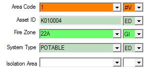
Here is an example of flagged data from a property sheet.
Tips:
- Choose a light colour for flags. Text on the grids and property sheets is always displayed in black print. Using dark colours for flags can obscure your data.
- Setting your monitor to a higher colour depth (greater than 256 colours) will give you a much better selection of available light colours. With a smaller palette, some colours are dithered (made up of a mixture of the available colours) and the dotted effect can obscure the text.
Built-in flags
There are a number of different built-in flags available in InfoWorks WS Pro. They are usually used to show the origin of data or to mark data for some form of automatic update.
All the built-in flags start with the # character, to differentiate them from user-defined flags. Built-in flags cannot be created or deleted. To prevent confusion, it is not possible to use the # character in user defined flags.
InfoWorks WS Pro includes the following standard data flags:
- #A (Asset) indicates a value imported from asset data
- #D (Default) indicates a default value. The value will be calculated from any combination of:
- A fixed default value.
- Other values in the same object (for example length of a polyline, or polygon area).
- Values in other objects in the same network.
- #G (Geographical) indicates a value generated from external geographical data. This external data is loaded into the GeoPlan window to carry out the process of setting these values, and is not part of the network. To reset the values, you must repeat the process.
- #I (Imported) indicates a value imported from model data.
- #N (Node) indicates a value generated from existing network node data.
- #V (CSV) indicates a value that has been imported or updated from CSV data.
More about #D
The values used to calculate the default value are always values within the same network, or a constant value. This is a unique property of #D.
Setting a data flag to #D will ensure that InfoWorks WS Pro updates the data whenever the object changes, or when other nearby objects that might affect the value are changed. If you edit a cell with a #D flag, the flag is removed.
Note: The length of a polyline or the area of a polygon is treated as part of the network data, even though projection information from the GeoPlan is used to calculate the actual area. For this reason the #D flag must be used when you want length or area values to be calculated from the polyline or polygon.
Obsolete flags
Users without Administrator privileges cannot delete data flags from the list, but can mark them as obsolete.
Flags can be marked as being obsolete by selecting the Obsolete box in the User Defined Flags dialog. Data that already has an obsolete flag is still displayed with the flag, but the obsolete flag is not displayed in the list when you try to change a flag. Therefore no new data items can be assigned the obsolete flag.
