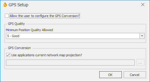
GPS Setup dialog
This dialog is to be used in conjunction with the GPS Coordinate object, available in the Form Designer. In this dialog, users can set the GPS conversion and minimum allowed quality for the recorded GPS data.
The dialog is displayed when the ellipsis button to the right of the GPS Settings property of the Application dialog is clicked.
Note that the GPS conversion can be set:
- for the whole application and all related formsand reports, via this dialog, or
- at run time, for each report, by the user in the field, via the GPS Information dialog, accessible by double-clicking the GPS coordinate on the corresponding report.
| Option | Description |
|---|---|
|
Allow the user to configure the GPS Conversion? |
Ticked by default. Check box determining if the GPS conversion of data provided by a connected GPS device can be set for the application (unticked) or at run time (ticked) for individual reports. See the GPS coordinate topic for more details. |
|
GPS Quality |
Available only if the GPS conversion is being set at application level (see above). Figure given by the GPS device for the quality of location fix. Values range from 1 - Ideal to 20 - Fair. |
| GPS Conversion |
Available only if the GPS conversion is being set at application level (see above). The check box determines whether or not the application's current network projection is to be used for the GPS conversion. Default is checked. If the check is removed or the browse button is clicked, a Choose Coordinate System dialog is displayed from which you can select the appropriate coordinate system. The conversion information will be used for GPS data when the corresponding button configuration states GPSConversion on the GPS Button Editor. |
|
OK |
Commits the changes and closes the dialog. |
|
Cancel |
Cancels the changes and closes the dialog. |

