Importing InfoWorks RS Network Data
InfoWorks RS network data can be imported from csv files exported from InfoWorks RS. To export the data to the csv file in the correct format for import into InfoWorks ICM, the following options should be checked on the CSV Export dialog in InfoWorks:
- Export each table to same file
- Include database field names
- Include object type column
- Use InfoWorks native units
Coordinate Arrays and Other Arrays Format options should be set to Packed.
To import network data from an InfoWorks RS CSV file:
- Open the network to be updated
- Select Import | Model | from RS CSV network data... from the Network menu. This displays a standard Windows File Open dialog.
- Select the csv file to be imported and click Open.
For details of the objects imported and conversions made by the importer, see the Conversion Notes below.
Conversion Notes
This section discusses how InfoWorks ICM converts existing InfoWorks RS network components into InfoWorks ICM network objects. Some data is not imported at all, or is only partially imported.
The InfoWorks RS objects currently supported are listed below with links to sections in this topic containing further detail on conversion:
| Conversion Notes Section | InfoWorks RS Object |
|---|---|
| River Reaches |
River Section Replicate Section Interpolate Section Links (between sections) Lateral Spill Inline Spill Junction Node |
| Bridges |
USBPR Bridge Arch Bridge Associated spill unit |
| Floodplain Sections | Floodplain Section |
| Boundary Nodes and Subcatchments | Boundary node and associated Subcatchment |
| Storage Areas | Storage Area |
| Conduits |
Circular Conduit Rectangular Conduit Sprung Arch Conduit |
| Weirs |
Gated Weir Round Nosed Broad Crested Weir Sharp Crested Weir Broad Crested Weir Gated Weir |
| Culverts |
Culvert Inlet Culvert Outlet |
| Sluices | Vertical Sluice |
| Orifices | Orifice (Outlet Type = Open) |
| 2D Objects |
2D Simulation Polygon 2D Point Source 2D Boundary Roughness Polygon Porous Wall Mesh Polygon 2D IC Polygon Porous Polygon |
| General Objects |
General Line General Polygon |
| Subcatchments |
Lateral Links |
| InfoWorks RS Object | InfoWorks ICM Object | Conversion Notes |
|---|---|---|
|
River Reach Cross Section Line Bank Line |
Imported to an InfoWorks ICM River Reach. Spills and sections are also imported as River Lines to allow modifications to section data. See below for details. |
| Inline Spill |
Bank Line Inline Bank |
InfoWorks RS Spill Units connected by in-line spill links are imported as InfoWorks ICM Bank Line and Inline Bank objects:
The exception to the above are in-line spill units associated with a bridge (see below). |
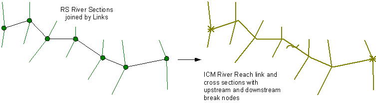
River Reach Import
InfoWorks RS river sections, links and lateral spills are imported to an InfoWorks ICM River Reach.
RS River sections and links are assembled into an InfoWorks ICM reach as follows:
- Upstream and downstream nodes of the RS reach are imported as InfoWorks ICM break nodes.
- RS river section nodes along the reach are imported as river reach sections in the InfoWorks ICM river reach.
- RS links connecting RS river section nodes are imported as a InfoWorks ICM river reach link.
-
RS junction nodes are imported as break nodes. Any river reach that is connected to a junction will be connected to the break node corresponding to the junction, rather than getting its own break node. Connectivity link geometry will not be imported.
- RS interpolate nodes are imported as a section interpolated from the sections upstream and downstream of the interpolate node. A break node is inserted at the node location, splitting the river reach and the new section is used as both the upstream section of the downstream reach and the downstream section of the upstream reach.
- RS replicate nodes are imported by copying the previous river section node. Elevations are calculated by subtracting the Drop in Bed Level value from the river section elevation values.
- Roughness type is set to N (Manning's n)
A Cross Section Line object is also imported for each InfoWorks RS section to allow modifications to section data in InfoWorks ICM.
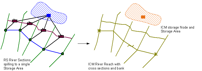
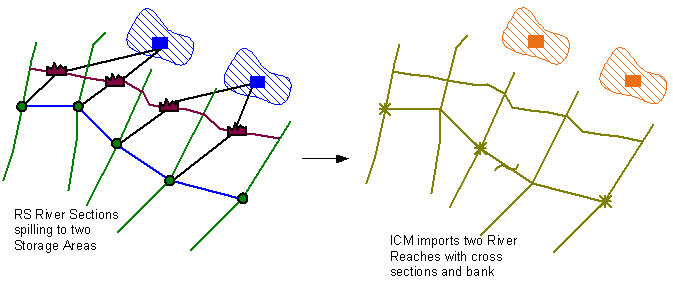
Banks
InfoWorks RS lateral spill units are used to form the left and right banks of an InfoWorks ICM River Reach.
A Bank Line object is also imported for each InfoWorks RS spill unit to allow modifications to bank section data in InfoWorks ICM.
Splitting Reaches
It is not always possible to import linked InfoWorks RS river sections as one continuous InfoWorks ICM river reach.
Reaches are split whenever:
- spills start spilling into a different object
- a line of spills on either bank begins or ends
- an interpolate node is encountered
The river reach link is split at the relevant section and a break node is inserted. The section at the split location is copied so that it is used at both the upstream section of the downstream reach and the downstream section of the upstream reach.

Due to the difference in the approach to modelling bridges in InfoWorks RS and InfoWorks ICM, it is not possible to directly import RS bridge data to the InfoWorks ICM bridge object. The importer attempts to generate bridge data from available RS information.
The user should review the imported data and make amendments as necessary.
InfoWorks RS USBPR and Arch bridge information is used to generate InfoWorks ICM Bridge and Cross section line objects.
- A Bridge link is created between upstream and downstream nodes:
- The link will be created between remote upstream and remote downstream river section nodes if these exist.
- If the RS bridge does not reference an upstream / downstream river section node, the us / ds node will be used instead.
- Unless there is a single RS spill unit associated with the bridge (see next point below), the US node ID of the RS bridge is imported into the Asset ID field of the Bridge link.
- If a single spill is connected between the upstream and downstream nodes of the bridge, the geometry of the InfoWorks RS spill unit is imported into the Bridge deck data of the Bridge:
- The modular limit and weir coefficient of the InfoWorks RS spill unit are imported to the Modular limit and Discharge coefficient fields of the bridge deck data.
- Bridge deck Roughness values are set to zero.
- The object ID of the InfoWorks RS spill unit associated with the bridge is imported into the Asset ID field of the Bridge link.
- A cross section line is also generated from the spill unit geometry.
- Upstream and downstream cross section lines are created:
- If bridge deck data has been generated from a spill unit, the point of intersection with the bridge will be set at 2/3 of the distance between the connecting node and the deck. The cross section lines will be created parallel to the deck.
- If bridge deck data has not been generated, the point of intersection with the bridge will be set at 1/3 and 2/3 of the distance along the bridge link. The cross section lines will be created parallel to the upstream/downstream river reach section.
- The chainage at which the cross section line intersects the bridge link is set as the chainage at the minimum elevation.
- Openings are created from RS bridge opening data:
- Openings are positioned midway between the left and right offsets of the cross sections
- Shape ID is set to ARCHSPRUNG
- Width is calculated as the difference between left and right offsets
- Opening US invert level and DS invert level values are set as the lowest elevation in the RS bridge section data.
- Height and Springing height are calculated from soffit height and spring height values relative to the US/DS invert level.
- Note that pier information is not imported.
- If bridge deck data has not been generated from RS spill unit data a cross section line for the bridge deck is created:
- The bearing of the cross section line is calculated as the average bearing between the river sections on each side.
- Elevation is set as one meter above the highest of the max elevation of the RS bridge section data or the highest point of the bridge openings
The bridge building tools are then applied to generate bridge section data.
| InfoWorks RS Object | InfoWorks ICM Object | Conversion Notes | ||||||||||
|---|---|---|---|---|---|---|---|---|---|---|---|---|
| Floodplain Section | Irregular Weir |
InfoWorks RS Foodplain Sections are imported as InfoWorks ICM Irregular Weirs with the following mappings:
|
Data from InfoWorks RS boundary nodes of event type Simple Runoff and PDM and their associated subcatchments are imported into InfoWorks ICM.
The geometry of subcatchments associated with other boundary node types is also imported.
InfoWorks RS boundary nodes of event type Simple Runoff are imported into InfoWorks ICM as subcatchments with SRM runoff fields populated from the RS boundary node simple runoff fields.
- If the boundary node has an associated subcatchment, the subcatchment geometry is also imported.
- If the boundary node does not have an associated subcatchment, a subcatchment with area equal to the boundary node's catchment area is created.
If one or more RS simple runoff boundary nodes are imported:
- A new Runoff Surface object with Runoff volume type set to SRM is created.
- A new Land Use object with Land use ID set to SRMn (where n is a positive integer) and Runoff surface 1 set to the ID of the new runoff surface object is created.
- The Land use ID of all imported SRM subcatchments is set to the ID of the new land use object
The simple runoff fields of the InfoWorks ICM subcatchment are populated from the values of the simple runoff fields in the InfoWorks RS boundary node as follows:
| InfoWorks RS boundary node field | InfoWorks ICM subcatchment field |
|---|---|
| Node | Node ID
Subcatchment ID (if the RS boundary node does not have an associated subcatchment) If an associated subcatchment exists, Subcatchment ID will be set to the RS Subcatchment ID. |
| Catchment Area | Total area |
| Runoff Coefficient | SRM runoff coefficient |
| Constant Flow | Not imported |
| Rainfall Time Delay | SRM time delay |
| Linear Time Const. 1 | SRM linear time constant 1 |
| Linear Time Const. 2 | SRM linear time constant 2 |
| - | Baseflow calculation set to None |
| - | Soil moisture deficit set to Event |
InfoWorks RS boundary nodes of event type PDM are imported into InfoWorks ICM as a Subcatchment and referenced PDM Descriptor object.
- If the boundary node has an associated subcatchment, the subcatchment geometry is also imported.
- If the boundary node does not have an associated subcatchment, a subcatchment with area equal to the boundary node's catchment area value is created.
If one or more RS PDM boundary nodes are imported:
- A new Runoff Surface object with Runoff volume type set to PDM is created.
- A new Land Use object with Land use ID set to PDMn (where n is a positive integer) and Runoff surface 1 set to the ID of the new runoff surface object is created.
- The Land use ID of all imported PDM subcatchments is set to the ID of the new land use object
The subcatchment fields are populated from the RS data as follows:
| InfoWorks RS boundary node field | InfoWorks ICM subcatchment field |
|---|---|
| Node | Node ID
Subcatchment ID (if the RS boundary node does not have an associated subcatchment) If an associated subcatchment exists, Subcatchment ID will be set to the RS Subcatchment ID. |
| Catchment Area | Total area |
For each PDM boundary node imported, a PDM Descriptor object named RS_PDM_<boundary node id> is created. The PDM Descriptor field in the InfoWorks ICM subcatchment is set to the name of the newly created PDM Descriptor object
The fields in the PDM Descriptor are populated from the values of the PDM Parameters fields in the InfoWorks RS boundary node as follows:
| InfoWorks RS boundary node field | InfoWorks ICM PDM Descriptor field | ||||||||||||
|---|---|---|---|---|---|---|---|---|---|---|---|---|---|
| Rainfall and evaporation | Rainfall and evaporation
|
||||||||||||
| Rainfall factor | Rainfall factor | ||||||||||||
| Actual evaporation function exponent | Evaporation exponent | ||||||||||||
| Infiltration rate parameter | Infiltration rate parameter | ||||||||||||
| Infiltration factor | Frozen infiltration rate parameter | ||||||||||||
| Time constant | Frozen time constant | ||||||||||||
| Moisture storage distribution | Soil moisture distribution
|
||||||||||||
| Min storage capacity | Minimum storage capacity | ||||||||||||
| Max storage capacity | Maximum storage capacity | ||||||||||||
| Pareto exponent | Pareto exponent | ||||||||||||
| Recharge and runoff | Recharge/runoff
|
||||||||||||
| Ground recharge time constant | Ground recharge time constant | ||||||||||||
| Soil tension storage capacity | Soil tension storage capacity | ||||||||||||
| Recharge function exponent | Recharge function exponent | ||||||||||||
| Initial value of soil moisture storage as a proportion of the maximum | Initial soil moisture proportion of max | ||||||||||||
| Proportion of runoff entering the surface-flow store | Surface flow runoff proportion | ||||||||||||
| Proportion of runoff entering the baseflow store | Baseflow store runoff proportion | ||||||||||||
| Groundwater deficit ratio threshold | Groundwater deficit ratio threshold | ||||||||||||
| Maximum recharge rate | Maximum recharge rate | ||||||||||||
| Groundwater demand factor exponent | Groundwater demand factor exponent | ||||||||||||
| Surface flow | Surface store
|
||||||||||||
| Linear reservoir 1 time constant | Linear reservoir 1 time constant | ||||||||||||
| Linear reservoir 2 time constant | Linear reservoir 2 time constant | ||||||||||||
| Interflow | Interflow
|
||||||||||||
| Interflow time constant | Interflow time constant | ||||||||||||
| Interflow factor | Interflow factor | ||||||||||||
| Base flow | Baseflow store
|
||||||||||||
| Baseflow time constant | Baseflow time constant | ||||||||||||
| Time and flow | Not imported | ||||||||||||
| Time delay | Time delay | ||||||||||||
| Additional flow | Not imported |
InfoWorks RS boundary nodes of event type other than Simple runoff or PDM are not imported into InfoWorks ICM.
Any subcatchments associated with these boundary nodes will be imported as InfoWorks ICM subcatchments.
| InfoWorks RS subcatchment field | InfoWorks ICM subcatchment field |
|---|---|
| Subcatchment ID | Subcatchment ID |
| Boundary Node ID | Node ID |
| InfoWorks RS Object | InfoWorks ICM Object | Conversion Notes |
|---|---|---|
| Storage Areas | Storage Node and associated Storage Area |
InfoWorks RS storage areas are imported as an InfoWorks ICM Storage Node with associated Storage Area if the RS storage area has a polygon boundary defined. The Ground level of the Storage Node will be set to the lowest level in the Storage array. River reaches will be linked to Storage Nodes using the Left node ID and/or Right node ID fields as appropriate. |
| InfoWorks RS Object | InfoWorks ICM Object | Conversion Notes | ||||||||||||||||||||||||||
|---|---|---|---|---|---|---|---|---|---|---|---|---|---|---|---|---|---|---|---|---|---|---|---|---|---|---|---|---|
| All supported conduit types | Conduit |
InfoWorks RS conduit nodes connected by links are imported as a single InfoWorks ICM Conduit (unless the roughness or shape changes or the pipe splits / meets a junction). Replicate / interpolations are translated as a duplicate of the upstream conduit.
|
||||||||||||||||||||||||||
| Circular Conduit | Conduit |
InfoWorks RS Circular Conduits are imported as InfoWorks ICM Conduits with Shape ID set to CIRC. The following mappings are specific to circular conduits (see above for common mappings for all conduit types):
|
||||||||||||||||||||||||||
| Rectangular Conduit | Conduit |
InfoWorks RS Rectangular Conduits are imported as InfoWorks ICM Conduits with Shape ID set to RECT. The following mappings are specific to rectangular conduits (see above for common mappings for all conduit types):
|
||||||||||||||||||||||||||
| Sprung Arch Conduit | Conduit |
InfoWorks RS Sprung Arch Conduits are imported as InfoWorks ICM Conduits with Shape ID set to ARCHSPRUNG. The following mappings are specific to sprung arch conduits (see above for common mappings for all conduit types):
|
| InfoWorks RS Object | InfoWorks ICM Object | Conversion Notes | ||||||||||||||||||||||||||||
|---|---|---|---|---|---|---|---|---|---|---|---|---|---|---|---|---|---|---|---|---|---|---|---|---|---|---|---|---|---|---|
| Gated Weir | Weir |
InfoWorks RS Gated Weirs are imported as InfoWorks ICM Weirs with Link type set to GTWeir with the following mappings:
|
||||||||||||||||||||||||||||
| Round Nosed Broad Crested Weir | Weir |
InfoWorks RS Round Nosed Broad Crested Weirs are imported as InfoWorks ICM Weirs with Link type set to BRWeir with the following mappings:
|
||||||||||||||||||||||||||||
| Sharp Crested Weir | Weir |
InfoWorks RS Sharp Crested Weirs are imported as InfoWorks ICM Weirs with Link type set to Weir with the following mappings:
|
||||||||||||||||||||||||||||
| Broad Crested Weir | Weir |
InfoWorks RS Broad Crested Weirs are imported as InfoWorks ICM Weirs with Link type set to Weir with the following mappings:
|
| InfoWorks RS Object | InfoWorks ICM Object | Conversion Notes | ||||||||||||||||||||||||||
|---|---|---|---|---|---|---|---|---|---|---|---|---|---|---|---|---|---|---|---|---|---|---|---|---|---|---|---|---|
|
Culvert Inlet Culvert Outlet |
Culvert Inlet Culvert Outlet |
InfoWorks RS Culvert Inlet and Culvert Outlet objects are imported as InfoWorks ICM Culvert Inlet and Culvert Outlet objects with the following mappings:
|
| InfoWorks RS Object | InfoWorks ICM Object | Conversion Notes | ||||||||||||||||
|---|---|---|---|---|---|---|---|---|---|---|---|---|---|---|---|---|---|---|
| Vertical Sluice | Sluice |
InfoWorks RS Vertical Sluice objects are imported as InfoWorks ICM Sluice objects with the following mappings:
|
| InfoWorks RS Object | InfoWorks ICM Object | Conversion Notes | ||||||||||||||||
|---|---|---|---|---|---|---|---|---|---|---|---|---|---|---|---|---|---|---|
| Orifice (Outlet Type = Open) | Sluice |
InfoWorks RS Orifice objects are imported as InfoWorks ICM Sluice objects with the following mappings:
|
| InfoWorks RS Object | InfoWorks ICM Object | Conversion Notes |
|---|---|---|
| 2D Simulation Polygon | 2D Zone |
InfoWorks RS 2D Simulation Polygons are imported as InfoWorks ICM 2D Zones. River reaches will be linked to 2D zones using the Left 2D zone ID and/or Right 2D zone ID fields as appropriate.
Note
The RS csv exporter does not support export of the 2D mesh within the polygon. Re-meshing will have to be carried out in InfoWorks ICM. |
| 2D Point Source | 2D Point Source |
Only the 2D Point Source location (x and y) is imported from InfoWorks RS. Inflow at the point source must be defined after import due to differences in 2D Point source modelling between InfoWorks RS and InfoWorks ICM. |
| 2D Boundary | 2D Boundary |
Only the 2D Boundary location is imported from InfoWorks RS. Boundary conditions must be defined after import due to differences in 2D Boundary modelling between InfoWorks RS and InfoWorks ICM. |
| Roughness Polygon | Roughness Zone |
In InfoWorks RS, a Roughness Polygon is associated with a Roughness Zone. In InfoWorks ICM, the roughness value is stored with the Roughness Zone, therefore a Roughness value must be specified after import. |
| Porous Wall | Porous Wall |
Import is straightforward and field mapping self explanatory |
| Mesh Polygon | Mesh Zone |
Import is straightforward and field mapping self explanatory |
| 2D IC Polygon | 2D IC Zone |
Import is straightforward and field mapping self explanatory |
| Porous Polygon | Porous Polygon |
Import is straightforward and field mapping self explanatory |
The InfoWorks RS importer now preserves, as far as possible, lateral links from subcatchments to river reaches. If an InfoWorks RS subcatchment is connected to a boundary node that is connected laterally to a river link, then the corresponding subcatchment in InfoWorks ICM will be connected to the corresponding river reach link via the lateral links functionality. However, there are some caveats:
- The Override weights option in InfoWorks RS is available for individual lateral links connected to the same subcatchment, whereas the corresponding Lateral weights field in the InfoWorks ICM can only be set on a per-subcatchment basis. If all of the lateral links connected to a subcatchment in InfoWorks RS have Override weights set, then it is treated as if Lateral weights is set to User in InfoWorks ICM and the weights will be respected. Otherwise, it will be treated as if Lateral weights is set to Length, even if Override weights have been specified for one or more lateral links.
-
InfoWorks RS river links are amalgamated into river reach links on import to InfoWorks ICM. If an InfoWorks RS boundary node is connected to some but not all of the river links that form a single river reach link, then the InfoWorks ICM subcatchment will, in effect, drain laterally into the entire river reach link, not just the parts of it that were connected to the boundary node in InfoWorks RS. In many cases, this will improve the schematisation, but there may be circumstances in which modellers will wish to review the connectivity.
-
The undocumented lateral type Area in InfoWorks RS is not supported in InfoWorks ICM, and is ignored by the importer.
