Configure Map Layer dialog

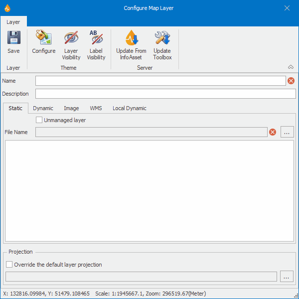
This dialog is used to configure new layers or edit existing layers.

The dialog is displayed when:

ClosedShow image

Option Description
Ribbon
Layer

Save

Save

Saves the changes and closes the dialog.
Theme

Configure

Configure

For all layer types with the exception of WMS layers: Launches the Map Layer Properties dialog, where display settings can be set for the layer.

For WMS layers only: Displays the WMS Layer Properties dialog, where the display of WMS layers can be configured (projection system, image format, colours and sub layer visibility).

Reset to default

Reset To Default

Available for the Local Dynamic layer type.

Layer visibility

Layer Visibility

Launches the Layer Visibility dialog, where layer visibility can be configured.

Label visibility

Label Visibility

Launches the Label Visibility dialog, where layer label visibility can be set. A warning message may be displayed if no labels have been configured.

Configure quick search

Configure Quick Search

Available for the Dynamic layer type.

Server

Update from InfoAsset

Update From InfoAsset

Opens the Get Data From InfoAsset dialog, which gives you the choice of updating either choice list data or user objects from InfoAsset.

Update toolbox

Update Toolbox

Updates the list of user objects in the toolbox. This will be effective if changes have been made to user objects in InfoAsset and the Update From InfoAsset command has been used to update user objects.

Name

Name of the layer.

Description

Layer description (optional).

Tabs

Note: Once a layer has been created, only the tab corresponding to its type will be present on the dialog.

Static

Layer type - static

Dynamic

Layer type - dynamic

Image

Layer type - dynamic

WMS

Layer type - web map service

Local Dynamic

Layer type - dynamic

Tab options

The following options are related to the layer type and are presented in tabs or pages within the dialog at layer creation time.

Unmanaged layer

Available for image and static layer types

This option is disabled by default.

This checkbox indicates whether the current layer is a managed (option disabled) or an unmanaged layer (option enabled):

  • Managed layers are managed by the InfoAsset Mobile server and as such are stored on the server where they can potentially take up a lot of space.
  • Unmanaged layers are locally maintained by the user and must be located in the Unmanaged map directory. The default location of this directory is set up in the Directories page of the Options dialog.

File Name

Available for image and static layer types

Filename - contains the path to the shape or image file. Initially blank at layer creation time.

Clicking the ellipsis button launches a standard Windows Open dialog allowing you to browse for a file.

URL

Available for WMS layer types

WMS server URL.

Clicking the ellipsis button launches the WMS URL dialog allowing you to enter a URL for the WMS server.

InfoAsset Manager/ Form dropdown list

Available for dynamic and local dynamic layer types

For selecting an InfoAsset Manager network object / form.

Show related information

Available for manhole survey local dynamic layers

Displays / hides the associated layer of inferred pipes on the map.

Note: This checkbox is the only means of controlling the display of the inferred pipe layer on the map. This layer being a pseudo layer, there is no legend available for it on the Layers tab of the Map Designer. However its symbology is entirely customisable like any other layer. See Configure, above.

Field list

Available for dynamic layer types

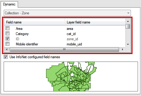
Initially blank at layer creation time, this section contains all the fields that are available for the selected InfoAsset Manager network object (see row above). Fields that will be represented in the layer have got their check box ticked.

Tick the checkbox adjacent to the fields you want to include in the layer.

Tip: A maximum of 250 fields can be selected. This is a shape file format limitation.

Use InfoAsset Manager configured field names

Available for dynamic layer types

When enabled, this option indicates that field names that have been defined by the user in InfoAsset Manager will be used in the layer definition in InfoAsset Mobile instead of the default names.

Layer preview

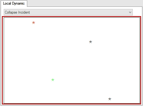
Initially blank at layer creation time, this view displays the layer as currently configured in the dialog. ClosedShow image

It is possible to zoom in and out on the Layer preview.

For dynamic layers, a grid is displayed at the top of the layer preview area, with the field names available for the related InfoAsset Manager object. ClosedShow image

Required fields and fields that are most likely to be picked by the user are automatically selected. Required fields are identified by their light grey colour. Required fields cannot be deselected whereas fields most likely to be picked by the user can.

Projection

Enabled for static and dynamic Shape layer types

Allows selection of a coordinate system to be associated with the layer.

This section contains two options that are related:

  • Override the default layer projection - Overrides the projection that been set as a default for the map.
  • Own projection box - This option is enabled when the Override the default layer projection checkbox is ticked.

Clicking the ellipsis button launches the Choose Coordinate System dialog where a projection system can be selected for the current layer.

Note: Local dynamic layers always use the default projection specified at application level, this is why this section is disabled for such layers. If no projection system is set for the application when a local dynamic layer is created, a warning will be displayed asking you to do so.

Layers and maps